Best at exposed breaks from Wednesday

Western Australia Surf Forecast by Craig Brokensha (issued Monday 9th March)
Best Days: Wednesday morning Margs and Gero, Thursday morning everywhere, Friday morning Margs and Gero, Saturday morning Margs
Recap
Saturday saw small to tiny surf across the state with favourable winds through the morning, while Sunday an inconsistent new W/SW groundswell pushed in offering good 4-6ft sets in the South West, 1-2ft waves around Perth and 3-4ft up at Gero with favourable winds through the morning (better than expected and from the E/SE around Margs).
This swell has dropped back into today but conditions were better with 3-5ft sets in the South West and 1-2ft waves around Perth.
 This week and weekend (Mar 10 - 15)
The surf will continue to drop through tomorrow with less than favourable S/SE winds around Margs, better offshores in Perth and NE winds up at Gero through the morning.
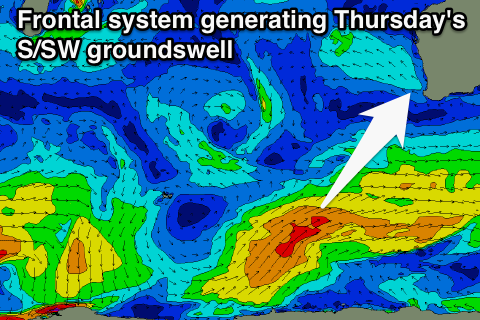
As touched on last week, we'll see some S/SW groundswell pulses filling in through the week, but the direction will limit the swell getting up into Perth and Gero with size.
The strength of the frontal progression generating these swells isn't anything special either, so we can expect Perth to hover in the tiny 1ft+ range, biggest through Thursday to 1-1.5ft. Gero is expected to be in the small and inconsistent 2ft to occasionally 3ft range.
Margs should see exposed breaks pulse hold 3-4ft Wednesday morning before pulsing late, while Thursday should see better 3-5ft sets. A slow drop from 3-4ft is due Friday and then further down into the weekend, bottoming out Sunday.
Winds will become more favourable from Wednesday with and E/SE offshore developing around Margs mid-late morning with similar winds to the north, persisting from a similar direction Thursday morning. Friday should see early variable winds ahead of a weak change and then offshores again into Saturday and Sunday morning's.
Longer term there's nothing too major on the cards with a general lack of polar frontal activity and more tropical instability in the form of tropical cyclones, but none will generate any meaningful swell. We'll have a closer look on Wednesday though.