Great conditions and fun swells for exposed breaks

Western Australia Surf Forecast by Craig Brokensha (issued Monday 2nd March)
Best Days: Every morning over the coming period in Margs and Gero, Perth tomorrow, Friday, Sunday and Monday
Recap
There wasn't much to get excited about over the weekend with a slow easing swell through Saturday with improving winds through the morning and then an afternoon kick in size yesterday as morning SE winds tended onshore.
Today a new SW groundswell is filling in across the state and conditions were clean across most breaks through the morning but winds have since gone more S'ly.
This week (Mar 3 - 6)
This afternoon's good pulse of SW groundswell is showing across the South West with the Cape Nat wave buoy on the rise and multiple swell trains showing on the cams. We should see Margs reach 4-6ft later today with Perth holding 1-2ft and Gero seeing the swell pulse tomorrow morning.
The swell should hold well into tomorrow morning across all coast but ease back in size from 4-5ft around Margs, 2ft on the sets in Perth and 3-4ft up at Gero mixed in with some short-range S'ly swell similar to today.
A small reinforcing S/SW groundswell from a secondary polar front just within our swell window to the south-west of us today is due Wednesday, but this should just keep exposed spots in the South West at 3-4ft, with tiny waves around Perth and 2-3ft surf in Gero.
Winds are looking great from tomorrow with offshore E/SE breezes that will only tend S/SE into the afternoon around Margs and hold out from the SE in Perth. Wednesday should see similar E/SE offshores through the morning and then E/NE winds Thursday as the S/SW swell backs away.
Friday's funky W/SW groundswell from ex-Tropical Cyclone Glenda is now looking a little less than inspiring, with the remnants of Glenda currently weakening well to our west, with a limited fetch of W'ly gales being aimed towards us. This system will continue to weaken while tracking south-east this evening and tomorrow, limiting the swell potential from this source.
We should still see a new W/SW groundswell showing possibly late in the South West Thursday, peaking early Friday morning to 3-4ft in the South West, an inconsistent 1-2ft in Perth and 2ft+ up at Gero. A similar sized long-range SW groundswell will also be in the mix in any case. Morning E/NE winds will continue to create favourable conditions through until the early afternoon.
 This weekend onwards (Mar 7 onwards)
Friday's mix of swells should ease back through Saturday under persistent E/NE winds, while into Sunday a mix of new long-range W/SW groundswell and better SW groundswell are due to build across the state.
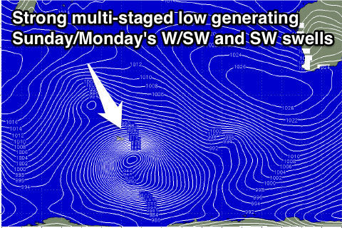
The source of these two swells will be the one storm, that being a vigorous and deepening low pressure system north-west of Heard Island, generating an initial fetch of severe-gale to storm-force W/SW winds through our far western swell window.
This low will dip south-east down to the polar shelf and then aim an additional fetch of severe-gale SW winds towards us, generating the secondary later arriving SW groundswell for Sunday.
The W/SW groundswell should arrive overnight Saturday and then peak Sunday morning to a very inconsistent 3-5ft in the South West, 1ft to nearly 2ft in Perth and 3ft+ up at Gero. The secondary SW groundswell should then arrive through the afternoon and pulse to 4-6ft in the South West, peaking Monday morning around Perth to 2ft, and 3-4ft up at Gero.
Conditions Sunday morning should remain good with moderate E/NE to NE breezes but come Monday a trough sitting to our west is finally due to push back inland bringing S/SE winds to the coast again. We'll confirm this all again on Wednesday though.