Fun swells on the way but with less than ideal winds

Western Australia Surf Forecast by Craig Brokensha (issued Monday 8th December)
Best Days: Tomorrow morning in protected spots, Wednesday morning and Thursday morning around Margs and Gero, Friday in protected spots, Saturday morning
Recap
Margs offered fun waves each morning across exposed breaks with winds tending offshore for a period each morning, while Perth was tiny and Gero only decent around dawn.
This week and weekend (Dec 9 - 14)
Our fun SW groundswell due tomorrow across the state is still on track, but so are the average S/SE winds. The South West should see inconsistent 4-5ft sets at exposed breaks with 1-1.5ft sets around Perth and 2-3ft waves up at Gero before easing back through Wednesday under more favourable SE winds during the morning (possibly E/SE at times across all locations).
Thursday morning will be the cleanest with morning offshore E/NE winds but we'll be in between swells up around Perth and Gero with exposed breaks around Geraldton the go.
Margs should see a new SW groundswell building through the morning coming in at 3-4ft+ early before pulsing to the 6ft range on the sets into the afternoon. Therefore a morning and midday surf should provide fun options across the South West Thursday.
This groundswell will be an initial SW pulse ahead of a larger increase on Friday generated by a couple of vigorous polar lows firing up in our south-west swell window.
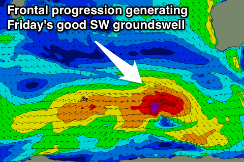 An initial fetch of W/SW gales will generate Thursday's building swell but also set up an active sea state for a stronger polar low to move over with an additional fetch of SW gales being generated in our swell window. This should produce a good but inconsistent SW groundswell for Friday coming in at 5-6ft in the South West, 1-2ft in Perth and 3-4ft up at Gero.
Winds will unfortunately be poor as a trough moves through resulting in a return to fresh and gusty S/SE winds Friday morning across all coasts that'll improve into Saturday and swing SE as the swell starts to back away.
Therefore protected locations will be the go on Friday and less so Saturday morning.
Sunday should also see morning SE winds but a low point in swell to 3-5ft in the South West, 1ft+ in Perth and 2-3ft up at Gero.
Monday onwards (Dec 15 onwards)
We're looking at a good pulse of SW groundswell into early next week but again winds look to spoil the party and swing onshore as it builds and back to the S/SE as it eases.
We'll have another look at this on Wednesday though.