Small windows of opportunity

Western Australia Surf Forecast by Craig Brokensha (issued Wednesday 26th November)
Best Days: Thursday morning exposed breaks, Monday morning protected spots, Tuesday morning
Recap
The South West and Gero offered the best waves yesterday as the swell really started to wane under stiff offshore winds. Today the surf is smaller again but nice and clean with 3ft sets in both Margs and Perth at exposed breaks. Perth was clean but near flat.
A new small pulse of swell has since filled in across Margs and Perth as winds backed off creating good conditions for the afternoon.
 This week and weekend (Dec 27 - 30)
Today's small lift in swell across the state will back off through tomorrow from 3-4ft in the South West, 1-1.5ft in Perth and 2-3ft up at Gero under favourable offshore E/SE winds around Perth, E'ly winds in Margs and NW tending variable winds to the north around Gero.
A new slightly stronger SW groundswell is due to fill in Friday but to no major size above 3-5ft at exposed spots in the South West 1-1.5ft in Perth and 3ft up at Gero into the afternoon. This swell should ease back just a notch Saturday and further into Sunday ahead of a late increase in size (discussed below).
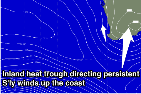
Winds will unfortunately be average and from the S/SE-SE each morning from Friday through the entire weekend as a persistent inland heat trough squeezes the north-eastern flank of a strong blocking high in the Indian Ocean. This will initially be S/SW around Margs Friday and then more from the S'th Saturday before going S/SE.
Next week onwards (Dec 1 onwards)
A couple of stronger SW groundswell pulses are due into Monday and Tuesday morning from a couple of stronger polar fronts firing up in the Heard Island region over the coming days.
The best swell is due Monday, peaking through the afternoon to 4-5ft in the South West, 1-2ft in Perth and 3ft+ later up at Gero. A secondary pulse for Tuesday should keep similar sized sets hitting both coasts before easing slowly into the afternoon and Wednesday, further Thursday.
Winds look to continue their trend from the S/SE to S/SW Monday but come Tuesday winds should clock offshore from the E/SE before going onshore and to the West Wednesday as the inland trough drifts further east.
So make the most of Tuesday morning!
Longer term there's still nothing major on the cards at all, so try and plan around the coming small windows of marginal surf.