Slow week of waves ahead

Western Australia Surf Forecast by Craig Brokensha (issued Monday 24th November)
Best Days: Tuesday morning exposed coasts, Wednesday morning swell magnets in the South West
Recap
The weekend was poor all around with a large easing swell through Saturday and further Sunday with onshore winds.
Today winds swung offshore as a reinforcing S/SW groundswell eased along with the SW swell from the 4-5ft range in the South West, 2ft in Perth and 3ft up at Gero.
This week (Mon 25 - 28)
Tomorrow morning will be clean again but the swell will be fading with an easing 3ft to occasionally 4ft wave at exposed breaks in the South West, 1-1.5ft in Perth and 2-3ft up at Gero under straight E/NE winds (E'ly around Margs).
Come Wednesday the swell is expected to bottom out with exposed spots in the South West the only option for a surf under morning E/NE winds.
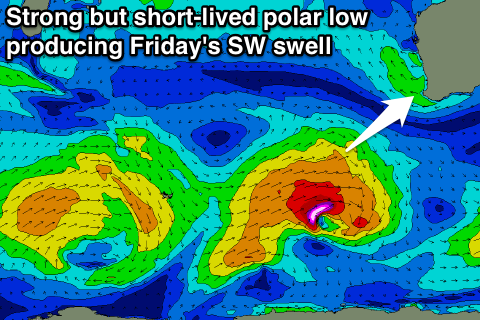 A weak trough/low that was forecast to develop off our coast during the middle of the week will take a different form and will form further south and west of us before breaking down later in the week.
This will result in winds remaining more favourable and from the E/SE down at Margs Thursday morning with variable winds around Perth but onshore NW winds around Gero as a small SW groundswell arriving through Wednesday backs off.
A stronger SW groundswell is due to fill in Friday but winds will unfortunately freshen from the S'th and tend S/SW into the afternoon as the trough starts drifting east.
Margs should build to 4-6ft through the day, with 1-2ft sets in Perth later, while Gero should see the swell peaking Saturday morning to 3ft+ under S/SE winds.
This weekend onwards (Nov 29 onwards)
There's still nothing major on the cards for us through the weekend and next week besides small to moderate pulses of SW groundswell.
Winds look to persist from the S/SE as well as an inland heat trough remains near stationary most of next week. We'll have another look at this on Wednesday though.