Slow end to the week, pumping Sunday with a large easing swell

Western Australia Surf Forecast by Craig Brokensha (issued Wednesday 8th October)
Best Days: Friday morning everywhere with a small slow swell, later Saturday in the South West, Sunday everywhere, Monday and Tuesday everywhere
Recap
Locations north of Margs were the pick again yesterday morning with an easing swell, while today similar conditions were seen across all coasts with a smaller swell and less favourable S'ly winds around Gero.
This week and weekend (Oct 9 - 12)
An increase in W/SW groundswell due this afternoon should ease back slowly through tomorrow and winds will continue to be unfavourable for Margs with a fresh but easing S/SW breeze.
Perth and Gero also look dicey with the S/SW breeze, with Gero probably performing the best with a lighter S/SE breeze through the morning. Therefore it's probably worth giving tomorrow a miss across all locations.
Friday morning should be clean across all coasts as a variable breeze develops in the South West, offshore E/SE winds around Perth and SE'ly breezes around Gero, but the swell will bottom out and be quite small (3-5ft in the South West at exposed breaks).
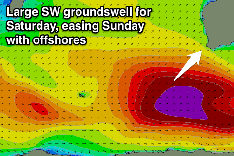 Late in the day though a strong long-range but very inconsistent W/SW groundswell should fill in but winds will be onshore by then. Of greater interest is a closer-range and larger SW swell due to build through Saturday and peak through the late afternoon.
This is already starting to be generated by a vigorous polar frontal progression firing up in the Heard Island region under the influence of a strong node of the Long Wave Trough positioned just to our west.
A pre-frontal fetch of W/NW gales will set in motion an active sea state for a fetch of stronger gale to severe-gale W/SW winds to move over to our south-west.
This should produce a large SW groundswell that's expected to reach the 10ft+ range in the South West Saturday afternoon, 3ft+ in Perth and 6ft+ up at Gero (holding a similar size Sunday morning after a peak overnight).
Winds on Saturday morning will be less than favourable and from the S/SE tending S/SW into the afternoon around Perth and Gero while Margs looks to see W/NW winds ahead of a late S'ly change, so possibly protected locations near dark are the go.
Sunday is much better with winds quickly swinging around to the E/SE as the swell eases creating excellent conditions.
Next Monday onwards (Oct 13 onwards)
Saturday's SW swell should continue to ease into the start of next week but winds will remain favourable for exposed spots with offshore E/NE winds for the most part.
Longer term there's nothing too major on the cards with moderate amounts of SW swell with variable winds, so make the most of Sunday/Monday/Tuesday.