Large dangerous swell Saturday, plenty of swell to follow

Western Australia Surf Forecast by Craig Brokensha (issued Monday 8th September)
Best Days: Saturrday for experienced surfers, Sunday morning, Monday morning, Tuesday morning, Wednesday, Friday
Recap
Both Perth and Gero offered good waves the last two mornings (including today) with medium to large amounts of easing swell. Margs saw variable winds each morning at dawn before quickly coming up from the west.
This weekend and next week (Sep 13 - 19)
There's been no change to the large, powerful long-period W/SW groundswell due across the state tomorrow with the fore-runners due to arrive this evening before the bulk of the swell fills in from midday tomorrow, peaking at some stage through the afternoon.
The Margaret River region should build to an inconsistent 12-15ft with 20ft+ sets at offshore reefs and bommies while Perth should build to 3-5ft during the afternoon, with Gero reaching 8-10ft later in the day.
Winds are expected to be offshore from the E/SE across most breaks tomorrow morning with moderate sea breezes expected across most breaks into the afternoon.
 The swell should ease steadily through Sunday from 8-10ft in the South West, 3-4ft in Perth and the 8ft range around Gero with variable winds in the South West, E'ly offshores around Perth and SE winds around Gero.
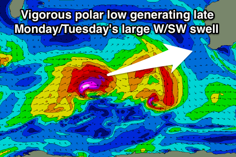
Monday morning is expected to be a low point in swell but into the afternoon, a secondary strong and large long-period W/SW groundswell is due.
This is will be produced by a smaller frontal system compared to the polar low that generated tomorrow's swell, but core wind speeds should still reach the severe-gale to storm-force range.
This polar low will push nicely towards us, producing another good long-period W/SW groundswell.
The South West should build to 8-10ft+ later Monday before easing from 8-10ft Tuesday morning. Perth should kick back to a more consistent 3ft late, before easing from a similar size Tuesday, with Gero probably not seeing any major size until Tuesday when 6ft+ sets are due.
Winds will be fresh from the S'th in any case Monday afternoon while Tuesday should see more favourable E/SE winds through the morning.
Wednesday looks great with straighter offshore E/NE winds as the swell continues to back off.
Our next significant increase in swell isn't far away, with another solid SW groundswell due across the state on Friday.
This will be generated as a vigorous polar frontal progression pushing from the south-east of South Africa, pushes across the Heard Island region while generating a fetch of severe-gale W/SW winds Sunday and Monday before weakening Tuesday.
The swell should fill in Friday, peak during the day to 6-8ft in the South West, 2-3ft in Perth during the afternoon and 4-5ft up at Gero late. Morning offshores are again expected from the E/SE with S/SW sea breezes.
Longer term another amplification of the Long Wave Trough is expected to strengthen through the Southern Indian Ocean around the 18th of September, likely producing large pulses of swell into the week starting the 22nd, but we'll review this Monday. Have a great weekend!