Fun days ahead, tricker later week

Victorian Forecast by Craig Brokensha (issued Monday March 25th)
Best Days: Surf Coast today and tomorrow morning, along with Wedneday morning, beaches Friday from mid-morning onwards, Saturday morning keen surfers
Features of the Forecast (tl;dr)
- Large SW-S/SW groundswell building this afternoon, easing tomorrow
- Moderate sized mid-period SW swell also in the mix tomorrow
- Moderate W/NW-NW winds tomorrow morning, shifting S/SW early PM and freshening
- Easing mix of swells Wed with light S/SW-SW winds, freshening (W/NW early Surf Coast)
- Smaller Thu with moderate S winds
- Small, inconsistent mid-period SW swell building Fri PM, easing slowly Sat
- E/SE tending E/NE then NE winds Fri ahead of sea breezes
- Small SW groundswell also in the mix Sat
- Light, local offshore winds Sat AM, shifting S into the PM
- Strengthening S/SW winds Sun with a building S/SW groundswell
- Easing groundswell Mon with SW winds (possibly W early Surf Coast)
- Moderate sized + SW swell for mid-late next week with SW winds, likely W'ly early on the Surf Coast
Recap
Onshore winds spoilt conditions into Saturday with moderate amounts of swell but nothing to really recommend surf wise.
Yesterday, conditions cleaned up on the Surf Coast with a fresh pulse of moderate sized mid-period SW swell, coming in at 3-4ft on the magnets with fairly favourable winds all day.
This morning we’ve got a bit more size again with clean conditions on the Surf Coast and surf to the 3-5ft range. We should see a stronger pulse of groundswell arriving into this afternoon as winds shift more W/SW-SW. More on this below.
This week and weekend (Mar 26 - 31)
Today and the coming days will be the pick of the period for the Surf Coast with moderate to large levels of swell and favourable conditions each morning.
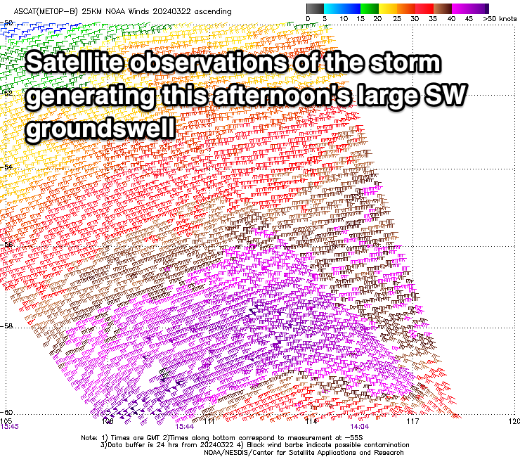
Our large SW groundswell for this afternoon is on track, with a strong polar low that fired up to the south-southwest of Western Australia on Friday, generating a fetch of gale to severe-gale W/SW winds through our south-western and then southern swell windows. There were even a couple of storm-force barbs picked up by satellite observation, and with this we should see the Surf Coast reaching 6ft later this afternoon with 8ft sets on the magnets, 8ft or so to the east of Melbourne.
This swell will peak overnight and ease through tomorrow, but there’s been a downgrade in the secondary reinforcing SW swell, generated by strong W’ly winds moving in today. The front linked to this swell has been downgraded and is quite thinner, resulting in only 3-4ft of swell from this source on the Surf Coast, 5-6ft to the east.
Instead we’ll be relying on the easing S/SW groundswell energy that should be coming in at 4-6ft tomorrow morning on the Surf Coast and 6ft to possibly 8ft to the east. Winds look great tomorrow morning and W/NW, holding until early afternoon and then swinging S/SW while freshening.
Wednesday morning will see light S/SW-SW winds lingering across most locations, though the Surf Coast should see a light W/NW’ly, with onshore winds slowly increasing during the day.
Size wise, the Surf Coast will be easing from 3ft to occasionally 4ft (magnets) with 5ft+ sets to the east.
Into Thursday, the surf will continue to ease in size but with a moderate S’ly breeze, improving on Friday morning with a pre-dawn E/SE’ly due to shift E/NE and then NE through the morning, creating better and better conditions for the beaches.

We should see a slight lift in swell on Friday as a long-range, mid-period SW swell fills in, generated today and tomorrow by a healthy fetch of pre-frontal W/NW winds, south-west of Western Australia.
On the Surf Coast it only looks to come in at 2ft+, with better 3-4ft sets to the east. Into Saturday this swell is due to ease, though there’s a long-period signal showing, generated by very poorly aligned gale to severe-gale N/NW-NW winds, tracking south-east towards the polar shelf tomorrow and Wednesday.
With this only an inconsistent 2ft wave is likely to persist on the Surf Coast Saturday, 3ft to possibly 4ft to the east but with light, local offshore winds ahead of a shallow S-S/SE change early afternoon.
This change will consolidate through Sunday, with early light winds due to strengthen through the day, and swell wise, a flukey pulse of S/SW groundswell is due to build into the afternoon. This will be generated behind the fetch of N/NW-NW winds, with a tight, polar fetch of severe-gale W/SW winds likely boosting the Surf Coast to 2-3ft, with 4ft+ sets to the ease but with the freshening onshore winds.
We’ll then enter a short period of small surf with poor winds thanks to dominate high pressure and troughy, local weather.
A possible early variable wind Monday will strengthen from the S’th with easing levels of S/SW groundswell from Sunday.
Tuesday looks to see SW winds along with some new, mid-period SW swell on the build, followed by some stronger swell later in the week.
The source of these swells will be a strengthening area of frontal activity south of the country later this weekend and into next week, with an initial fetch of strong W/SW winds likely to reach gale-force. This will see building levels of swell in size and period, likely peaking next Thursday/Friday.
Winds at this stage look to be generally out of the south-western quadrant, with periods of lighter W/NW winds due early each morning. More on this in the coming updates.
Comments
So what does that all translate for the bells comp?
2 days on then off for a week.
Possibly.
Enjoy a white and dark chocolate Easter egg or two .Drive safely.