Small beachy options, then poor from Tuesday afternoon

Victorian Surf Forecast by Craig Brokensha (issued Friday March 15th)
Best Days: Exposed beaches tomorrow, Sunday, Monday morning and Tuesday ahead of the change
Features of the Forecast (tl;dr)
- Easing mix of SE windswell and background SW swell tomorrow with E/NE-NE tending SE mid-late PM
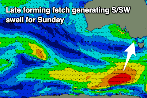
- Small, building S/SW swell Sun, peaking in the PM, easing Mon
- NE winds Sun, tending SE later PM, NE all day Mon
- Moderate + sized W/SW groundswell building Tue, peaking later with strengthening N winds, tending S/SW later morning
- Easing swell Wed with strong S winds
- Smaller Thu with fresh S/SE winds, S/SW Fri
Recap
Poor, deteriorating surf through yesterday with strengthening S/SE winds, lighter and doable to the east in the morning. Today winds are more to the E/SE and conditions are better on the beaches with a mix of swells to 3ft+ or so, bumpy and 2-3ft on the Surf Coast.
Winds will strengthen from the E/SE-SE through the day, kicking up a localised pulse of SE windswell.
This weekend and next week (Mar 16 - 22)
The weekend looks to be a fun one for the exposed beaches.
Today's strengthening SE winds will ease and tip E/NE-NE tomorrow morning, creating improving, peaky waves with a mix of easing SE windswell from 2ft to occasionally 3ft on the Surf Coast early and background SW swell energy to 3ft to occasionally 4ft to the east.
Winds should hold until mid-afternoon before shifting back SE thereafter and strengthening.
NE winds will develop into Sunday but with an early, temporary low point in swell, ahead of some new mid-period S/SW swell into mid-late morning. As touched on in Wednesday's update, the source is a late forming fetch of W/SW winds on the polar shelf this morning, with a kick to 2-3 on the Surf Coast, 3-4ft to the east. Winds look to hold until mid-afternoon again, tending SE later afternoon so there should be plenty of time to surf the new, small pulse of energy.
Monday looks small and easing with fading 2ft sets max, 2-3ft to the east and with NE winds that look to last all day, if not tending E'ly temporarily later afternoon.
Tuesday looks to start slow ahead of some building W/SW groundswell under strengthening N'ly winds, shifting S/SW later morning and becoming strong into the afternoon.
This change will be linked to the backside of a strong low moving in from a position to the south-west of Western Australia, linked to our moderate + sized pulse of W/SW groundswell that's due to fill in Tuesday afternoon.
This groundswell looks healthy, with a fetch of gale to severe-gale W/NW winds due to generate a spike to 4ft on the Surf Coast Tuesday afternoon, 6ft to the east, easing from 3-4ft and 5-6ft on Wednesday.

There might be a window of building surf ahead of the change Tuesday worth making the most of, with Wednesday being poor thanks to strong S'ly winds in the wake of the change.
Thursday and Friday unfortunately both look poor as will with persistent onshore winds thanks to swell generating fronts clipping Tasmania. This will generate small to moderate levels of swell but with average conditions.
Longer term the outlook is slower with no reprieve in the onshore flow next weekend, improving the following week but with fading surf. So with this in mind make the most of the small beachy waves over the coming days. Have a great weekend!
Comments
Hopefully not another repeat of last years bells comp brewing. Was terrible
If - and ONLY IF - it rains on the grand prix then I can accept this.
Little Sunday bump in size didn’t seem to happen?
Looks like it was running late. A few bigger lines coming through now.
Hi Craig. Never confident with early Easters and Bells. Will you do a forecast at some stage?
Yep, will have one tomorrow.
Incoming bombing low south of vicco over weekend??
Looks a bit spicy doesn’t it sr
Indeed, for a short burst of solid swell...although it's moving away to the SE as it bombs so not ideal alignment maybe.