Improving conditions with a rapidly easing swell
Victorian Forecast by Craig Brokensha (issued Monday March 4th)
Best Days: Tomorrow morning, Friday morning to the east, Saturday, Sunday morning
Features of the Forecast (tl;dr)
- Large S/SW groundswell this morning, easing this afternoon and rapidly tomorrow with E/NE tending N/NE winds ahead of sea breezes to the east, N/NW winds developing to the west ahead of sea breezes
- Small leftovers Wed, with a possible S/SE groundswell in the mid with N-N/NW winds, shifting S/SW later AM and freshening into the PM
- Small to tiny Thu with S/SE winds
- Moderate sized W/SW swell for later Thu, but more so Fri with E/NE-E winds to the east, E/SE to the west ahead of sea breezes
- Easing swell Sat with N/NE winds
- Smaller Sun with N/NW tending S/SW winds
Recap
Saturday morning was fairly lumpy and not great with a limited window of early W/SW winds on the Surf Coast, quickly shifting onshore as some stronger W/SW groundswell filled in.
This was replaced by more consistent mid-period swell into yesterday with much cleaner conditions under morning offshore winds. The Surf Coast came in around 4-5ft+ with quality options west of Melbourne, best in more protected locations to the east.
This morning, we’ve got an even larger pulse of S/SW groundswell from a significant low that formed on the tail of all the activity linked to the surf since last Friday. This is coming in at a strong 8ft across the Surf Coast but fresh S/SE winds are severely limiting options.
This week and weekend (Mar 5 - 10)
This morning’s large pulse of S/SW groundswell will ease this afternoon and drop steadily through tomorrow thanks to the low that generated it moving rapidly through our swell window on the weekend.
Thanks to the low moving quickly to the east, a high will also quickly swing winds back offshore tomorrow morning, with an E/NE tending N/NE breezes due east of Melbourne along with winds tending N/NW across the Surf Coast through the morning (early will likely be a little lumpy still). Sea breezes will develop into the afternoon but not overly strong.
Easing 3ft to possibly 4ft sets are due early on the Surf Coast, back to 2-3ft into the afternoon with easing 4-5ft sets to the east thanks to the southerly direction of the swell.

Wednesday looks smaller with 1-2ft leftovers to the west and 2ft sets to the east, but as touched on last week, there might be some sneaky S/SE groundswell sneaking in around Flinders Island across selected spots later Tuesday and into Wednesday morning for savvy surfers. This will be generated off the backside of the low when it moved south of the Tasman Sea, projecting severe-gale to storm-force S’ly winds northward.
Winds on Wednesday look N-N/NW, shifting S/SW and freshening with a change through the later morning and afternoon.
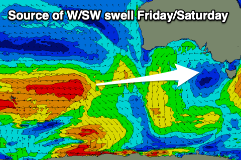
This trough will leave S/SE winds into Thursday with no decent swell, better Friday as winds shift E/NE and some new, mid-period W/SW energy fills in.

The source of this swell is a healthy but distant frontal progression kicking up to the south-west of Western Australia, generating back to back fetches of strong to gale-force W’ly winds. The progression will weaken while moving east, slowly under the country through the week and this should extend the swell longevity into the weekend.
The peak is due Friday with inconsistent but good 3ft+ sets due on the Surf Coast (4ft magnets), 4-6ft to the east and with that morning E-E/NE breeze, easing slowly from 3ft and 4-5ft respectively Saturday morning under better N/NE offshore that look to last all day. Sunday looks smaller with early N/NW winds ahead of a S/SW change, with more activity due into next week. More on this Wednesday.


Comments
Cold cold wind on Sunday morning (car dash said 9* just before sunrise in the carpark) - water warm enough for boardies but air cold enough for a 3/2. Seasons be changing!
The BH report (8am) is very inconsistent. Only getting done every so often. Torquay is spot on each day. Any reason why?
Craigos... any chance of a consistent multi-day swell event with longer windows of off-shores?
These short windows on weekend morning's aren't doing anyone favours with spreading out the crowds!