Fun beachy waves for the coming days, bigger but onshore for the weekend

Victorian Surf Forecast by Craig Brokensha (issued Monday February 26th)
Best Days: Exposed beaches tomorrow and Wednesday, Surf Coast Thursday and Friday mornings, keen surfers early Saturday Surf Coast, beaches early-mid next week
Features of the Forecast (tl;dr)
- Building W/SW swell this afternoon, easing tomorrow with E/NE-N/NE tending SE winds later tomorrow
- Small, background swell Wed with fresh N/NE winds, strengthening later
- Small W/SW swell Thu with W/NW tending S/SW winds, strengthening
- Moderate sized W/SW swell Fri with W/NW tending W/SW then SW winds
- Moderate sized W/SW groundswell Sat with gusty SW tending S/SW winds (likely W/NW early)
- Easing swell Sun with S winds
- Moderate sized, reinforcing swell for Sun PM and Mon AM with E tending SE winds
- Easing swell Tue with N/NE winds
Recap
Saturday came in large but onshore with a couple of options for savvy surfers out of the wind, much better yesterday with clean, improving conditions and a drop in swell back from 3ft+ on the Surf Coast and 4ft to the east.
An onshore change moved in through the afternoon but more so the evening, poor this morning with smaller amounts of swell.

Fun surf yesterday AM
This week and weekend (Feb 27 – Mar 3)
Into this afternoon, some new, inconsistent mid-period swell is due, generated by a distant polar front to the south-west of Western Australia last week.
Slow but fun 2ft to occasionally 3ft waves are due on the Surf Coast magnets this afternoon and tomorrow morning, 4ft on the sets to the east and with improving conditions.
A moderate to fresh E/NE tending NE breeze is due tomorrow morning, creating improving conditions, variable into the afternoon ahead of late sea breezes.
Wednesday looks smaller but holding 2ft on the Surf Coast and 3-4ft to the east with a reinforcing pulse of swell under fresh N/NE winds that will strengthen into the evening ahead of an incoming trough. The Surf Coast may see winds swing onshore into the afternoon but to the east it should remain clean all day.
Thursday will remain on the smaller side of the coin with favourable W/NW offshore winds, shifting W/SW into the early afternoon and then gusty S/SW after as the trough moves across us.
Swell wise, we should start to see some moderate sized, mid-period W/SW energy arriving through Friday though it won't be until the weekend that stronger levels of energy are due, mainly Saturday with a reinforcing pulse for Sunday afternoon and Monday.
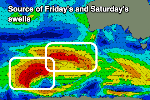
The source of the coming swells will be a strengthen Southern Ocean frontal progression firing up to the south-west of Western Australia. An initial weak front that's currently south-west of WA will generate Thursday's swell, while a stronger low behind it should produce pre-frontal W/NW-W gales, followed by pos-frontal W/SW-W gales.
This should generate Friday's and Saturday's swells, with Friday coming in around 3ft+ on the Surf Coast with 4-6ft sets to the east, stronger Saturday and to 4-5ft (likely odd bigger one magnets) and 6-8ft respectively west and east of Melbourne.
Conditions on Friday morning look great with a W/NW breeze, shifting S/SW into the afternoon and strengthening. Saturday unfortunately looks to see gusty SW-S/SW winds (though early will offer W/NW offshores on the Surf Coast), with Sunday seeing S'ly winds persist as a high moves in behind the activity, spoiling the swell.
So unfortunately not as exciting as it was looking last Friday.
A good reinforcing pulse of swell is due Sunday afternoon and Monday as wind start to improve, though only being E'ly in the morning, much better for the beaches next Tuesday with a N/NE offshore and a fun sized, easing swell.
Offshore winds look to persist most of the week as the swell continues to fade but we'll have another look at this on Wednesday.
Comments
Craig the difference between a 11 second swell and 14+ is major on this coast. Banks that didn't work now fire albeit in a more gutless form. No idea how up north works at 9 seconds as down here it would be Dungers (Mals) only.
We've got less continental shelf so 9s comes in quite nice and still has a bit of punch. 9-11s or so. Upwards of that you can really feel the power. Pretty funny eh.
Got it so if down here had less shelf it would be mostly unsurfable. Too big, too solid for the beachies most of the time and bells would be like Hawaii.
Yeah likely. It amazed me when I moved from South Australia, how even the windswells here are surfable and fun, on the right board that is. Whereas back home it's just too weak and gutless mostly.