Poor week, improving weekend

Victorian Surf Forecast by Craig Brokensha (issued Monday February 5th)
Best Days: Saturday, Sunday, Tuesday next week
Features of the Forecast (tl;dr)
- Easing swell tomorrow with moderate-fresh S/SW winds
- Smaller Wed with weaker S/SW winds (likely light W early on the Surf Coast)
- Small, weak SW swell Thu with mod-fresh S/SE winds
- Fading swell Fri with gusty S winds
- Large S/SW groundswell building Sat, peaking in the PM with light-moderate S/SW-S winds
- Easing swell Sun with variable offshore tending S winds
- Moderate sized reinforcing S/SW swell for Mon PM and Tue with variable S winds, increasing from the S/SE Mon
- Strengthening N/NE-N/NW winds Tue
Recap
What an incredible weekend of surf. Our large S/SW groundswell that showed into Friday afternoon and evening cleaned up beautifully into Saturday morning with large 6-8ft waves across the Surf Coast with the odd bigger bomb in the mix, easing through the day with workable sea breezes.
Yesterday morning was temporarily smaller but nice and clean with options to the east, coming in at 4-5ft but another strong pulse of strong groundswell arrived through the day though with bumpy conditions again into the afternoon. Not enough to ruin the swell though.
Winds backed off into the evening ahead of a stronger S/SW change overnight, creating bumpy conditions with good, moderate sized surf.
As touched on Friday, I hope you made the most of the weekend as the coming period is now quite average.
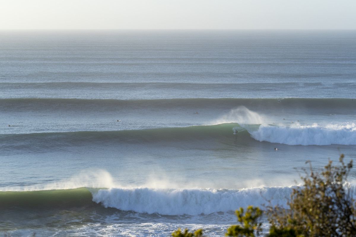
Magic Saturday (Romy Becker-Roache)
This week and weekend (Feb 6 - 11)
So now that the onshore wind is in and the significant swell generating storms have passed, we've got a subdued week of activity along with generally average winds and conditions.
The current swell generated by the 'bombing' low will fade into tomorrow with lingering, moderate to fresh S/SW winds. There's a very tiny chance for lighter W winds in pockets on the Surf Coast but it's not worth chasing.
Weaker S/SW winds are due on Wednesday, with a greater chance of a light W'ly on the Surf Coast but we'll be looking at fading 1-2ft sets.
A very small lift in mid-period SW swell is due on Thursday, generated by a weak passing under the country tomorrow, but S/SE winds will create average conditions with 2ft sets max on the Surf Coast, 3ft+ to the east.
Friday will be another lay day with gusty S winds and fading surf.
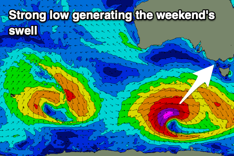
Moving into the weekend, a strong low is forecast to fire up in our south-western swell window as another tropical low in the Indian Ocean tracks south-east and is absorbed into the westerly storm track.
The low won't quite bomb, but we should still see it strengthen significantly, generating a fetch of severe-gale to storm-force W/SW-SW winds through our south-western and then southern swell windows. EC has this system a little weaker than GFS so we'll have to review this size, but we can expect a large pulse of S/SW groundswell Saturday, building to 6ft+ across the Surf Coast magnets later afternoon/evening, (6-8ft) to the east but with S/SW-S winds. Winds aren't expected to be overly strong so conditions should be workable as the swell kicks.
Sunday looks fun as the swell backs off steadily with light, local offshore winds but easing sets from 4ft or so on the Surf Coast, 5-6ft to the east.
Into next week, moderate sized levels of reinforcing S/SW groundswell are on the cards with varying winds, likely best Tuesday but more on this in the next update.
Comments
What a wonderful weekend of waves!
Just curious Craig.. from memory the wave size chart for Sat morning was only showing 4-5ft whereas your forecast notes and the actual waves on the day were quite a big larger. I know the charts arent always the most accurate but was there a particular feature of Saturday's swell that meant it was undersized on the charts?
I was happy with my choice of surfing somewhere more sheltered after I saw footage of some of the sets that rolled through at the magnets.
I'd say the south direction of the swell with the current modelling. Always comes in bigger.
is there going to be a photo dump for us mexcians to re-live the glory moments from saturday C.B.
Unfortunately we don't get sent many galleries any more. Straight to socials :(
ya got ya. insta was good when #tag was in date/day chronological order. you could pretty much see the whole swell live. now its a hyw of garbage with top posts or recent top posts. unless you randomly follow people who take pictures of the surf its very limited what is out there to look at. mainly what google/meta puts up in your face is what you are able to see. noted if this swell was in qld it would be like the nfl superbowl was playing in coolangatta. yet us mexicans get waves and its like mehh.
maby thats a good thing.
Hah yes. We should run Stu's question about wave size on the WOTD of the bowl. Bigger than 4 - 5.