Cleaner options into the weekend with smallish surf

Victorian Forecast by Craig Brokensha (issued Wednesday January 3rd)
Best Days: This morning, Saturday morning to the east, Sunday to the east, Monday morning
Features of the Forecast (tl;dr)
- Small sized S/SW swell for the end of the week, peaking Fri, easing Sat
- Fresh S/SW winds tomorrow, possibly easing through the AM
- Fresh SE winds Fri
- E-E/NE tending SE winds Sat with easing surf
- E/NE tending NE winds Sun with a small mix of swells
- Late increase in small SW swell Sun, peaking Mon with a slightly bigger pulse Tue/Wed
- NE tending NW winds ahead of a S/SW change Mon, gusty SW Tue
Recap
Lighter winds out of the east yesterday morning provided better conditions across the beaches to the east of Melbourne with a good sized swell in the 4ft range, workable at selected spots on the Surf Coast and hanging in at 2-3ft.
A new pulse of S/SW swell through the afternoon provided a bit more strength to the sets but with fresh onshore winds, easing today with variable winds and lumpy conditions, best on the Mornington Peninsula.
This week and weekend (Jan 4 - 7)
Make the most of this morning’s cleaner conditions and variable winds as the end of the week looks poor thanks to a trough moving in from the west this evening, bringing freshening S/SE winds that will then shift S/SW into tomorrow morning.
Winds are due to ease off later morning tomorrow creating slightly cleaner conditions before freshening again into the afternoon. All in all it’ll be a lay day, similar Friday as winds shift to the SE and become gusty.
Swell wise, background levels of mid-period S/SW swell should maintain 2-3ft waves on the Surf Coast and 4ft surf to the east mostly through Friday, easing Saturday from 2ft+ and 3-4ft respectively.
Conditions will improve on the weekend as a broad, inland low drifts south-east from South Australia, shifting winds around to the E-E/NE during the morning ahead of S/SE sea breezes.
Sunday looks cleaner with a E/NE tending NE breeze but with smaller, weaker surf, fading from the SW and with some small SE windswell in the mix on the Surf Coast. Slow 2ft sets are due on the Surf Coast, 3ft+ to the east though clean on the beaches most of the day.
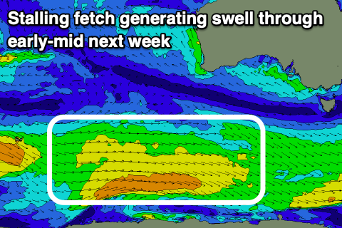
Later in the day, some new mid-period SW swell may be seen, generated by a healthy fetch of strong to near gale-force W/NW winds forming to the south-west of Western Australia today. The frontal system linked to this fetch will become slow moving, stalling on the polar shelf but in a weaker form through Friday and Saturday, prolonging the swell through early next week.
The first pulse for later Sunday and Monday looks to be 2-3ft on the Surf Coast and 4ft+ to the east, with a secondary better sized pulse for Tuesday reaching 3ft and 4-5ft respectively.
Winds on Monday look favourable for both regions, quickly shifting NE to NW through the morning ahead of a trough and afternoon S/SW change, that will unfortunately remain gusty from the SW Tuesday. More variable winds may be seen Wednesday as the swell eases, but more on this Friday.
Comments
Rouge set.

Whoa, whoa. No way Bells is bigger than Waimea, bro.
Nah. Bodhi was right.
Weird. If that was legit (and not an error in the buoy readings) it would be a world record for a rogue wave.
The period makes that more likely but nothing showed up on the Cape Sorell buoy.
The period rises to match it, 30s lol - also smaller aftershock. That's nuts.
Made me smile, 2 am, no witnesses.
Ha, 10,000 year swell, bummer, peaked overnight!