Very active period though with dicey winds

Victorian Surf Forecast by Craig Brokensha (issued Monday 13th November)
Best Days: Tomorrow Surf Coast, Wednesday morning, Saturday morning Surf Coast, Sunday morning
Features of the Forecast (tl;dr)
- Moderate sized SW swell building today (peaking tomorrow AM) with moderate SW winds (W/NW early Surf Coast), tending SW-S/SW from mid-late AM
- Large S/SW groundswell building tomorrow afternoon, peaking overnight, easing Wed
- Light S/SW winds Wed AM (possible variable pockets), tending S/SE-S through the day and freshening later
- Easing swell Thu with strong S/SW winds
- Small-mod sized reinforcing swell Fri with mod-fresh S/SW winds, strengthening
- Mod sized mid-period SW swell Sat with W/NW tending S/SW winds
- Large S/SW groundswell building later Sat, peaking Sun AM with variable tending fresh SE winds
Recap
An early onshore change and small swell wrote-off the surf for the Saturday, while our expected new W/SW swell yesterday provided a boost in size to the 3ft range across the Surf Coast, a little cleaner though still lumpy/bumpy.
Today we've got our better SW swell on the build with the Surf Coast coming in at 3-4ft on the Surf Coast with early light winds and clean conditions, now bumpy with a return to SW winds.
This week and weekend (Nov 14 – 19)
There's a ton of swell due over the coming days, but the local winds are the main issue, with periods of lighter breezes and cleaner conditions before we enter an average period into next week.
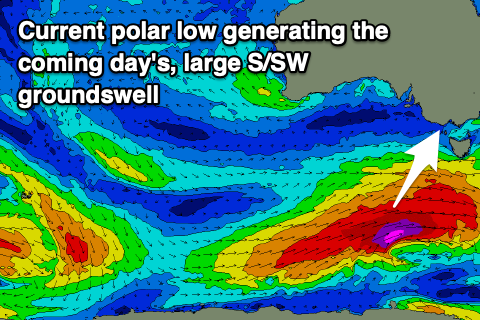
Firstly, looking at the current setup, and a healthy polar low that formed on the weekend is bringing today's building swell, with it due to peak tomorrow morning to 4-5ft on the Surf Coast and 6ft+ to the east, but we've had an upgrade in the strength of the trailing system.
This secondary low is now generating a significant fetch of severe-gale to storm-force W/SW winds in our southern swell window, generating a large S/SW groundswell for tomorrow afternoon, building rapidly and likely peaking overnight, easing Wednesday.
Size wise we're now looking at 8ft sets across the Surf Coast into the late afternoon/evening, 10ft to the east, easing back from 6-8ft and 8-10ft respectively Wednesday morning.
A continued easing trend is due through Thursday and Friday, still decent in size on the Surf Coast on the former and dropping from 4ft or so.
Looking at the local winds and a morning W/NW breeze is due tomorrow on the Surf Coast, SW to the east, shifting SW-S/SW on the Surf Coast mid-morning and then holding from the S/SW into the afternoon but without any major strength.
Wednesday looks a little dicey with a lingering S/SW breeze due across all locations, possibly variable in pockets tending S/SE-S through the day, freshening later.
The end of the week unfortunately looks poor as the eastern flank of a strong high sitting under Western Australia is squeezed by weaker, frontal systems pushing up and across Tasmania into the end of the week. This will bring strengthening S/SW winds on Thursday, easing temporarily on Friday but persisting from the S/SW, strengthening into the evening with a bit less swell.
Looking at the weekend ahead, and we've got another large, powerful S/SW groundswell on the cards, generated by one of the frontal systems pushing around the south-east corner of the high.

This almost looks to be a 'bombing' low, dropping 24hPa within a 24 hour period with GFS on board with this scenario, while EC is weaker and only drops 20hPa or so.
Regardless we're set to see a strong polar low forming, generating a fetch of severe-gale to storm-force SW winds in our southern swell window late week.
The groundswell is due to arrive late Saturday but peak Sunday to 6ft+ across the Surf Coast and 8ft+ to the east along with possible variable morning winds and fresh SE sea breezes.
We'll have to review the timing, size and local winds in Wednesday's and Friday's updates but following this, the high is due to move east from Western Australia as a surface trough off the East Coast deepens, bringing a poor run of strong E/SE-SE winds. More on this Wednesday.