Several windows of opportunity on the boil

Victorian Surf Forecast by Ben Matson (issued Friday 24th March)
Features of the Forecast (tl;dr)
- Building surf Sat with generally onshore winds
- Light variable winds Sun AM and a strong peak in groundswell, easing Mon
- W'y winds redeveloping Tues/Wed/Thurs with small/mod swells
- Renewal of strong surf Fri/Sat/Sun with winds out of the west
Recap
Small swells have built slowly since Thursday morning, when easterly winds created clean conditions east of Melbourne to groom 2-3ft sets. We’re now seeing a little more size but winds are around to the south so conditions are wobbly.
This weekend (Mar 25 - 26)
Onshore winds will persist on Saturday though they won’t be too strong, so conditions should be workable (though it probably won’t be worth any major highway miles).
Today’s surf will increase more prominently through Saturday towards a peak on Sunday morning. Early Saturday should see 3ft sets west of Melbourne but we’re likely to see 4ft, almost 4-5ft sets at the regional swell magnets early Sunday, before size tapers off into the afternoon. Expect another couple of feet on top at the open beaches east of Melbourne, with small peelers at Western Port late Saturday and Sunday.
Sunday’s conditions are still looking pretty good with Saturday’s onshore flow expected to throttle right back, becoming light and variable. Note: ‘variable’ means ‘from any direction (which could be onshore) however light morning land breezes are very likely which should create generally clean conditions at most coasts.
Next week (Mar 27 onwards)
Monday morning’s also looking good for a surf, with early light winds preceding an afternoon SE breeze that’ll create unwelcome lumps and bumps after lunch.
Size will be easing from Sunday but the Surf Coast should manage 3-4ft sets (down to 2-3ft by the afternoon), an east of Melbourne you’ll probably have to seek out some shelter as the open beaches will be maxing around 5-6ft to begin with.
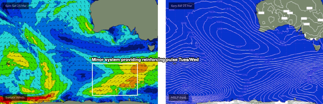
Westerly winds are then expected to redevelop through Tuesday and persist for the rest of the week. A small polar low developing SW of Tasmania over the weekend has been downgraded a little in the last few runs - and it's expected to flare up right on the eastern periphery of our swell window (see below) - but it should provide a small reinforcement in wave heights through Tues/Wed, though no major size is like (2-3ft sets west of Melbourne, outside chance for early W/NW winds).
The next swell sequence is expected to arrive on Friday, thanks to a strong polar low sequence forming east of Heard Island from Tuesday onwards. This system is expected to stall in its eastward track (that’s a good thing!), and size should build through Friday, holding Sat/Sun with embedded pulses pushing 3-5ft west of Melbourne and 6ft+ to the east.
It looks like there’ll be some form of westerly flow associated this event too, so all in all looks pretty stock standard synoptic pattern for autumn - nothing epic, but certainly an upgrade from what we've seen over the last few months - and hopefully a good warm up as we work towards the Easter period.
Have a great weekend, see you Monday!
Comments
Speaking of Easter Ben, when is the early forecast for Bells due to come out? Just curious.
Hi Ben, BOM seems to be going for strong SE winds on Tuesday with models all over place, before westerlies on Wednesday what likelihood do you place on these westerlies on Tuesday?