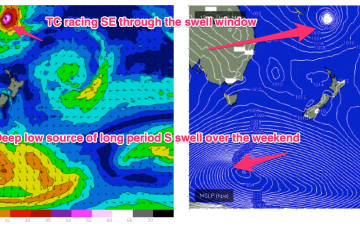
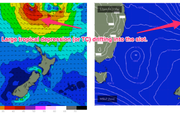
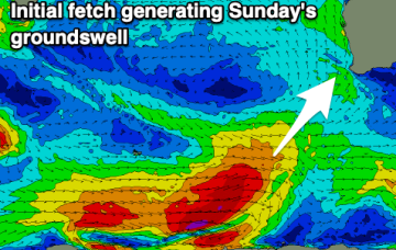
Plenty of swell but with south winds
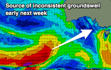
The South Coast will be poor all week, while the swells won't have enough west in the to provide any real size on the Mid Coast.
The troughy pattern will see rapid fire wind changes across temperate NSW this week and while all eyes are on the tropics it’s looking like a continuing tease with an expected tropical depression or TC moving quite quickly SE through the swell window with limited surf potential.
There's no clear standout day this period but there'll be flukey periods of lighter, more favourable winds along with plenty of swell.
No great changes to the weekend f/cast. High pressure is now moving SE towards the tip of the South Island, maintaining a SE-ESE trade flow in the Coral Sea. Tradewinds are being enhanced by an active monsoon trough extending from the Arafura Sea into the Coral Sea.
Troughy weather will bring dicey winds for the period, spoiling a good new swell for Monday.
No great change to the weekend f/cast. High pressure is now drifting SE towards the South Island with an approaching trough tightening the pressure gradient and leading to fresh N’ly winds for Eastern Tasmania .
Good winds with fun swells over the coming days before things go quiet.
Models are now firming on a large tropical depression (possibly a TC) drifting southwards into the slot between New Caledonia and the North Island from mid next week. A broad, slow moving area of E’ly low end gales is likely on the southern flank of this system, initially favouring the sub-tropics, but radiating down to temperate NSW through next weekend.
There's not much to work with this period unfortunately. There's a bit of swell inbound but with average winds.
Models are now firming on a large tropical depression (possibly a TC) drifting southwards into the slot between New Caledonia and the North Island from mid next week. A broad, slow moving area of E’ly low end gales is likely on the southern flank of this system, initially favouring the sub-tropics, but radiating down to temperate NSW through next weekend.