Tricky swells but generally increasing in size

Victorian Surf Forecast by Craig Brokensha (issued Friday 14th October)
Best Days: Sunday morning keen surfers both regions, Monday ahead of sea breezes, Tuesday morning on the beaches
Features of the Forecast (tl;dr)
- Weak W/SW windswell tomorrow AM
- Inconsistent, small SW groundswell for tomorrow PM
- Fresh NW tending W/NW winds ahead of a late PM S/SW change
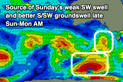
- Small mid-period SW swell Sun
- Moderate sized S/SW groundswell arriving late Sun, peaking Mon AM
- Light S/SW tending variable winds Sun AM, then moderate S into the PM (W/NW on the Surf Coast in the AM)
- Moderate sized SW groundswell for Mon PM with variable tending S/SE-SE winds
- Easing mix of swells Tue with NE tending S/SE-SE winds
- Smaller Wed with variable early winds, tending SE
Recap
Smaller, but workable surf to 2-3ft on the exposed beaches all of yesterday, 1-2ft early on the Surf Coast magnets but then easing, while today we've got tiny waves on the Surf Coast, 2ft sets on the Mornington Peninsula and 2-3ft waves across Phillip Island.
This weekend and next week (Oct 17 - 21)
Looking at the weekend ahead and it'll consist of small, slow swells, cleanest on the Surf Coast tomorrow with a weak, tiny W/SW windswell for the morning and inconsistent SW groundswell for the afternoon.
The windswell will be generated by a front pushing across us today, likely 1-1.5ft in the morning, while the inconsistent SW groundswell was generated by a very strong but very short-lived burst of storm-force W winds on the polar shelf this week. This should provide inconsistent 2ft sets into the afternoon on the Surf Coast, 3-4ft to the east. NW winds are due to shift W/NW through the day and then variable mid-afternoon ahead of a S/SW change into the mid-late afternoon.
On Sunday this swell will ease, replaced by a mid-period SW swell generated by a weak front pushing in quickly through our swell window today and early tomorrow, bringing later tomorrow's change.
 This doesn't look overly special at all but 2ft sets are due to persist on the Surf Coast, 3ft to maybe 4ft to the east. Winds look to linger out of the S/SW but only light, in the wake of Saturday's change, tending variable through the morning ahead of sea breezes. This will create improving conditions on the exposed beaches ahead of sea breezes, while the Surf Coast should see a light W/NW breeze in the morning.
Now, our better pulse of S/SW groundswell from a low attached to the weak front moving through today is on track for late Sunday but more so Monday.
The source of this swell will be a polar fetch of stalling W/SW gales on the polar shelf, tending more W'ly away from us while reaching severe-gale strength early tomorrow morning.
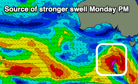 The swell from this system will be inconsistent but sets to 3ft are due on the Surf Coast Monday morning, 4ft to possibly 5ft to the east. Into the afternoon a stronger pulse of SW swell energy is now due, generated by a strong low forming south of Western Australia tomorrow, projecting a fetch of W/NW-W/SW gales through our swell window while dipping east-southeast and then out of our swell window Sunday afternoon.
A moderate sized SW groundswell is due from this source, pushing wave heights to 4ft on the sets on the Surf Coast, 5-6ft to the east.
Both swells will peak into the evening and then ease back through Tuesday from 3ft and 4-5ft respectively on Tuesday.
Coming back to the local winds and a variable breeze is expected on Monday morning, likely W/NW on the Surf Coast and N across Phillip Island, ahead of moderate S/SE-SE sea breezes, while Tuesday looks cleanest to the east with a NE offshore ahead of S/SE-SE sea breezes.
Winds on Wednesday still look dicey with a trough bringing S/SE-SE breezes that may be variable at dawn. Swell wise, the surf looks smaller and best on the beaches.
A new high pressure system will be semi-blocked by a deepening inland low to our north, resulting in fresher SE winds on Thursday, improving Friday with a new pulse of small-moderate sized SW swell. At this stage it looks to possibly come in around 2-3ft on the Surf Coast and 4-5ft to the east, but we'll have a closer look at this Monday. Have a great weekend!
Comments
Kneeboarders unite at spot Q Saturday morning.
The waves are looking pretty good today with that mix of new swells filling in!