Improving winds as the swell bottoms out

Victorian Surf Forecast by Craig Brokensha (issued Wednesday 5th October)
Best Days: Today selected locations to the east, tomorrow morning exposed beaches, Monday morning exposed beaches, later Tuesday and dawn Wednesday exposed beaches
Features of the Forecast (tl;dr)
- Fading mix of SW and SE swells tomorrow with fresh E/NE tending NE winds
- Tiny to flat Fri with N/NW winds ahead of a shallow SW change
- Inconsistent mix of W/SW and SW swells building Sat, peaking into the late PM, easing slowly Sun
- Mod-fresh W/NW tending strong SW winds Sat, moderate S-S/SE Sun
- Easing surf Mon with light E/NE tending SE winds
- Small pulse of mid-period S/SW swell for later Tue with gusty NE winds, easing Wed with N tending W/NW winds
Recap
Average and deteriorating conditions across all locations yesterday, though surfable through the morning across the beaches on the Surf Coast and locations to the east. The afternoon became poor as onshore winds strengthened.
Today we've got strong E winds and a stormy SE windswell to 3-5ft on the Surf Coast, while to the east there's a new SW swell to a similar 3-5ft, that'll ease through the day.
Conditions are windy, choppy and tricky but we should see more options develop into the afternoon as the swell starts easing and winds tend E/NE at times while also backing off a touch.

Windy, peaky surf on the exposed beaches this morning
This week and weekend (Sep 6 – Oct 9)
This morning's fresh pulse of mid-period SW swell is now peaking and we'll see it easing steadily over the coming 24-36 hours, bottoming into into later tomorrow and Friday morning.
There'll also be easing levels of SE windswell in the mix as winds improve due to the low linked to the current winds moving south-east while weakening. Gusty E/NE tending NE winds are due tomorrow, favouring the beaches along with easing 3ft sets in the morning, smaller and a slower 2ft into the afternoon. The Surf Coast looks to ease from a similar 2-3ft but from the SE.
 Come Friday there'll be no swell left and winds will swing to the N/NW ahead of a shallow, mid-afternoon SW change.
This will be ahead of a surface trough which still looks to bring W/NW winds on Saturday morning, shifting SW and strengthening into the afternoon.
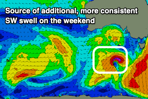
Our mix of W/SW and SW swells for the afternoon and Sunday are on track, with the W/SW energy being long-range, generated by a distant fetch of strong to gale-force W/SW winds east of the Heard Island region yesterday. A better, more consistent SW swell should be generated by the remnants of this system, strengthening south of the Bight tomorrow, aiming a slim fetch of W/SW gales through our swell window into the evening.
Both swells are due to build Saturday, being small with the morning W/NW offshore and peaking as winds go onshore into the later afternoon. Sets to 2-3ft are due on the Surf Coast later in the day, 4-5ft to the east easing from a similar size on Sunday.
 Winds will ease into Sunday but be lingering out of the S/SE-S, creating bump conditions. There's a slim chance for early W'ly winds on the Surf Coast but we'll have a closer look at this Friday.
Moving into early next week and variable E/NE winds should create cleaner conditions on the beaches but with easing surf from 1-2ft on the Surf Coast and 2-3ft to the east.
Unfortunately there's not much swell due through the rest of the week with weak, troughy weather due to dominate our swell windows from the weekend. A small pulse of mid-period S/SW swell may be seen later Tuesday and Wednesday morning with gusty NE winds on the former, N tending W/NW on the latter. Size wise it looks to be only 2-3ft on the exposed beaches to the east but check back here Friday for a clearer idea.
Comments
https://www.dailymail.co.uk/news/article-11285585/Urgent-tornado-warning...
Good luck to all crew in those areas
Well this is unusual.
Portsea cam - completely flat and glass.
Lorne cam - glass and a 1ft ridable wave.