Best over the coming days

Victorian Surf Forecast by Craig Brokensha (issued Wednesday 21st September)
Best Days: Today, Thursday for the keen, Friday, Sunday
Features of the Forecast (tl;dr)
- Inconsistent, moderate sized W/SW swell for tomorrow, strongest into the PM with light-mod S/SW winds (possibly light W early Surf Coast)
- Continuing inconsistent W/SW swell Fri with light NW tending S/SW winds early PM, strengthening thereafter
- Inconsistent, moderate sized W/SW groundswell later Fri, peaking Sat AM with strong S winds, abating and tending S/SW into the PM
- Easing swell Sun with early local offshore tending N/NE-NE winds, then E/NE-E into the PM
- Smaller Mon with strong N tending N/NW winds ahead of a mid-PM W change
- Inconsistent W/SW groundswell for later Mon, peaking Tue with strong SW winds
- Easing surf Wed and Thu with persistent SW-S/SW winds
Recap
Fun waves across both regions yesterday with an inconsistent W/SW groundswell to 3ft on the sets across the Surf Coast and 4-5ft to the east. Winds were best for the beaches but still decent for the reefs on the Surf Coast, with a slight drop in size seen into the afternoon.
This morning we've got a little less size and good conditions for the beaches again with 2ft waves on the Surf Coast and 3-4ft sets to the east. Winds are due to shift E/SE-SE into the afternoon east of Melbourne and S/SW across the Surf Coast but without too much strength.


Fun options this AM
This week and next (Sep 22 - 30)
From tomorrow we should see some better though inconsistent W/SW swell energy filling in across the state, generated by a distant but prolonged polar frontal progression that occured from the Heard Island region through to south-west Western Australia during the weekend and early this week.
Our first swell for tomorrow morning will be the least consistent, with a better reinforcing pulse due to arrive into the afternoon.
Infrequent 3ft sets are due on the Surf Coast tomorrow morning, 4-5ft to the east, with a touch more size due into the afternoon to 3ft+ and 5-6ft respectively.
Winds aren't great tomorrow (but more than workable), with a trough due to bring S/SW winds, light to moderate in strength and possibly lighter W'ly for a short period at dawn.
Friday looks better with a reinforcing pulse of W/SW energy due to maintain 3ft+ waves on the Surf Coast magnets and 5-6ft sets to the east with a light NW offshore ahead of another trough and strengthening S/SW change from early afternoon.
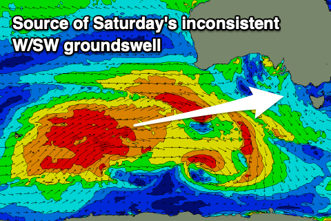 This change will unfortunately spoil our most consistent and best pulse of W/SW groundswell that's due to arrive later Friday and peak Saturday morning. The final polar front linked to this swell is currently weakening south-west of Western Australia, with it due to offer infrequent 3-4ft sets on the Surf Coast and 6ft waves to the east Saturday morning but with strong S winds, abating and shifting S/SW into the afternoon.
Sunday still looks to be the pick of the weekend for those not getting too carried away with the Grand Final on Saturday. A light, early local offshore wind is expected across both regions before tending N/NE-NE through the morning and E/NE-E into the afternoon.
Size wise, Saturday morning's groundswell will be on the ease, dropping from 3ft on the sets across the Surf Coast and 4-5ft+ to the east.
Come Monday the surf will be smaller and on the way out and a deepening trough moving in from the west will bring strengthening N winds, shifting N/NW ahead of a gusty W'ly change mid-late afternoon.
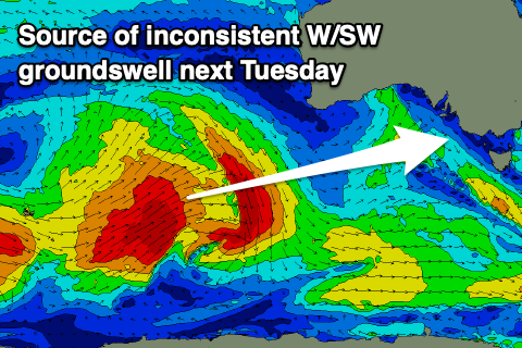 Later in the afternoon a new, inconsistent W/SW groundswell is due to start building, peaking Tuesday but with what looks to be strong SW winds in the wake of Monday's change.
This swell will be generated by a distant polar low developing around the Heard Island region and then weakening south-west of Western Australia again. It looks to come in at 3ft on the Surf Coast and 4-6ft to the east but with those poor winds.
Unfortunately the stalling nature of the trough will keep onshore S/SW-SW winds blowing through Bass Strait on Wednesday, shifting more S/SW Thursday while relaxing as a high slowly moves in from the west.
Stronger E/SE winds and a poor SE windswell looks likely into next weekend but we'll have a closer look at this on Friday. In the meantime make the most of the current fun conditions.
Comments
Am I the only one who was hoping that the best of the weekends conditions on the SC was going to be on Saturday just as Geelong run out onto the MCG?