Plenty of surfing options for the coming period

Victorian Surf Forecast by Craig Brokensha (issued Monday 19th September)
Best Days: Today ahead of an afternoon change, tomorrow, Wednesday morning on the beaches, Thursday for the keen, Friday, Sunday
Features of the Forecast (tl;dr)
- Inconsistent W/SW groundswell later today, peaking tomorrow with mod-fresh N/NE winds (tending N/NW at times to the west)
- Reinforcing W/SW swell Wed with E/NE-NE tending SE winds
- Inconsistent, moderate sized W/SW swell for Thu, with a secondary pulse for the PM, holding Fri
- Light S/SW winds Thu, increasing
- Light NW winds Fri, giving into a late W/SW change
- Moderate sized, inconsistent W/SW groundswell Sat with fresh SW winds (possibly W'ly early Surf Coast)
- Easing swell Sun with N/NE winds
Recap
With promising signs of small W/SW swell building through Friday, the weekend was expected to be a little better in size and consistency across the Surf Coast, but alas the waves stayed a slow 2ft max on the Surf Coast magnets, a bit bigger to the east but poor and wind affected.
Today has shown the most promise when the swell was expected to be on its downwards trend from the weekend, with clean, fun 2-3ft sets in protected spots on the Surf Coast, average and wind affected to the east again. Winds will shift SW into the afternoon as the size eases, so surf before lunch.
This week and weekend (Sep 20 - 25)
We've got a couple of fun days of surf due across the beaches as a new, inconsistent W/SW groundswell arrives later today and peaks tomorrow. This swell was generated by a poorly structured but strong polar low to the south-west of Western Australia and came in well across Margaret River yesterday, with it on track to maintain 2-3ft waves on the Surf Coast tomorrow with 4-5ft sets to the east.
An approaching mid-latitude low should swing winds to the N/NE tomorrow with it holding all day to the east, tending N/NW at times to the west.
Into Wednesday some reinforcing mid-period swell energy should maintain similar but weaker surf across both coasts along with an E/NE-NE tending SE breeze as the weakening mid-latitude low/trough pushes in and across us.
On the backside of the trough, lingering S/SW winds will create some bumps as the first in a series of stronger W/SW swells fills in.
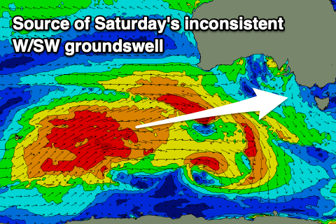
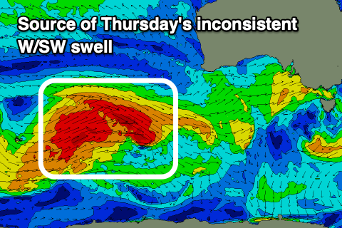 Three distinct but similar sized pulses of W/SW swell are due across the state from Thursday through Saturday, generated by a strong progression of polar fronts moving in from the Heard Island region, to the south-west of Western Australia.
Thursday's pulse was generated on the weekend by a fetch of gale-force W/NW-W/SW winds, with a secondary reinforcing swell due to arrive into the afternoon, generated by a shorter-lived fetch of W'ly gales to the south-west of Western Australia last night.
It'll be inconsistent but good sets to 3ft+ are due on the Surf Coast magnets, 5-6ft on the Mornington Peninsula but with that onshore, S/SW breeze.
 Friday looks cleaner and with light NW winds ahead of a late, strong W/SW change.
Late in the day Friday the strongest pulse of W/SW groundswell is expected, peaking on Saturday. This will be generated a fetch of W/SW gales developing south-west of Western Australia this evening and tomorrow morning, projecting north-east while weakening.
Size wise this swell looks to be an inconsistent 3-4ft on the Surf Coast and 6ft to the east but with gusty SW winds in the wake of later Friday's change. The Surf Coast may see a period of early W'ly winds but we'll have a closer look at this on Wednesday. Sunday at this stage looks the pick with a N/NE offshore and easing groundswell from 3ft on the sets across the Surf Coast, 4-5ft+ to the east.
Longer term we've got plenty more W/SW swell energy due across the state but with tricky winds as the mid-latitude systems linked to the surf move across us. More on this Wednesday.