Fun weekend of westerly swell

Victorian Surf Forecast by Craig Brokensha (issued Friday 16th September)
Best Days: This morning exposed beaches, later in the day Surf Coast, tomorrow and Sunday Surf Coast, Tuesday exposed beaches, Wednesday morning Surf Coast, Thursday and Friday mornings
Features of the Forecast (tl;dr)
- Inconsistent, small W/SW swell building today with gusty N tending N/NW winds
- Better W/SW swell tomorrow with strong N/NW winds
- Easing W/SW swell Sun with strong but easing NW winds
- Smaller Mon with early W/NW tending W/SW-SW winds
- Inconsistent W/SW groundswell later Mon, peaking Tue with fresh N/NE-NE winds
- Reinforcing W/SW swell Wed with variable tending S/SW winds
- Inconsistent, moderate sized W/SW swell building Thu, peaking Fri with a stronger groundswell Sat
- Variable offshore tending SE winds Thu and Fri, S/SE Sat
Recap
Effectively flat surf across all locations through yesterday with clean conditions but no swell. Into the afternoon the first hints of inconsistent W'ly swell started to show across Phillip Island, offering 2ft sets for the patient.
Today we've got a bit more energy filling in from the W/SW with 3ft+ sets across Phillip Island and the Mornington Peninsula with clean conditions, 1-2ft on the Surf Coast magnets but very slow. We should see the swell building further into the afternoon reaching an easy 4ft on the exposed beaches to the east and 2ft+ on the Surf Coast but with strengthening N/NW winds, so hit the exposed beaches now.


Good sized sets to the east this AM
This weekend and next week (Sep 17 - 23)
Today we're seeing the first pulse of W/SW swell from a strong, slow moving but poorly aligned mid-latitude low pushing in from the Bight.
 This was generated by the initial stages of the low as it formed immediately south-west of Western Australia and seeing the current lines pushing in through Bass Strait, it's all positive signs for tomorrow's better swell.
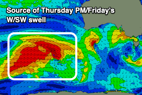
This better and more reliable pulse of swell was generated yesterday as the low broadened a little, with a fetch of strong to gale-force SW winds on it's backside developing a little further south and more in our swell window.
While aimed primarily up and into the Bight, the persistent nature of the fetch should generate some fun, side-band energy tomorrow coming in at 2-3ft on the Surf Coast magnets and to 5ft to the east.
Conditions will be best to the west of Melbourne with a strong N/NW breeze owing to the mid-latitude low moving in closer towards us, passing over us Sunday bringing strong but easing NW winds.
Size wise Sunday, we're due to see tomorrow's swell easing back from a similar 2-3ft and 5ft respectively across the Surf Coast and Mornington Peninsula.
There's no decent additional swell expected from the backside of the low and the models are incorrectly combining swells, so lower your expectations but there'll be fun waves across most breaks
The swells will ease further into Monday, likely from 2ft+ on the Surf Coast and 4ft to the east. Winds look to be W/SW tending SW following the backside of the low, but the Surf Coast should see a morning W/NW breeze.
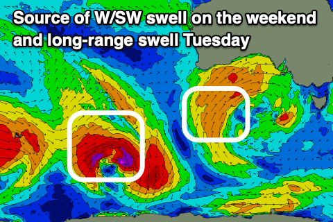
Later in the day Monday our inconsistent and small W/SW groundswell is still on track, with a peak due Tuesday. This was generated through yesterday by a strong but poorly structured polar low firing up to the north-east of the Heard Island region, with core wind speeds reaching storm-force but over a very small are and aimed mostly towards Western Australia.
 Size wise, the Surf Coast should see inconsistent 2-3ft sets with 4-5ft waves on the Mornington Peninsula Tuesday under great, fresh N/NE-NE winds, favouring the beaches.
Some lesser period but similar sized reinforcing mid-period W/SW energy is expected on Wednesday from distant, polar frontal activity but a trough is due to bring a S/SW change mid-morning with variable breezes due at dawn.
From later week we should see some inconsistent pulses of mid-period and groundswell energy out of the W/SW owing to a multi-threaded polar frontal progression firing up across the Heard Island region and to the south-west of Western Australia.
Back to back fetches of gale to near severe-gale-force W/SW and W/NW winds will generate moderate sized levels of swell, building Thursday afternoon, strongest and best on Saturday week.
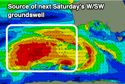 Size wise we're looking at inconsistent 3ft+ on the Surf Coast Thursday afternoon and Friday with 4ft sets most likely Friday, 5-6ft on the Mornington Peninsula, with Saturday seeing surf more in the 4ft range on the Surf Coast reefs, 6ft+ to the east.
Locally winds look generally light, variable and locally offshore in the mornings with troughy weather, giving into SE sea breezes. Saturday is looking dicey as a trough brings a S/SE change. We'll have to confirm this next week though. Have a great weekend!
Comments
Small, cold and a very long wait for 1-2 waves sets today. Those really W swells are no good.
Yeah spewing, seeing yesterday's increase today was looking good. But nope..
Tomorrow smaller again? Or a chance of a bit more size?
Same, same IMO. Localised windswell should give it a bit more consistency.
Thanks Craigos
An increase on dead flat is still bloody tiny :-/
Pt Nepean has doubled since yesterday, unfortunately period has plummeted. Direction not bad at 210 degrees. Still 1 maybe 2 ft. Very frustrating .
210 to 220 is a very west reading for Pt Nepean buoy, Cape Sorrell is between 260 and 280
1
Don't tell swellnet that. Anyway it's been a good size for the grommet's and stok
Yep, I just enjoy surfing as a regular activity. Don't only need it to be falling from the sky, 50 year storm stuff, quite happy to surf all the way down to 1-2ft. It's great, the fountain of youth as they say. You do you poo man, just seems sometimes you spend more time whinging about how bad the surfs been than actually surfing - may want to re-evaluate how you spend your time.
I’m with you stock, I will paddle out in anything and enjoy it. Your a spoilt human if you whinge about surf quality.
You said it finbob.