Tricky westerly swells for the weekend

Victorian Surf Forecast by Craig Brokensha (issued Wednesday 14th September)
Best Days: Today exposed beaches, Friday selected locations, Saturday Surf Coast, Sunday morning Surf Coast, Tuesday exposed beaches
Features of the Forecast (tl;dr)
- Tiny tomorrow with light-gusty N/NE winds
- Inconsistent, small W/SW swell building Fri PM with gusty N tending N/NW winds
- Better W/SW swell Sat with strong N/NW winds
- Easing W/SW swell Sun with gusty W/NW tending W winds
- Inconsistent W/SW groundswell later Mon, peaking Tue with N/NE winds
- Better moderate sized + W/SW groundswell later next week
Recap
Down, down, down. Monday's large S/SW groundswell was still solid and around the 4-5ft range on the Surf Coast magnets yesterday morning with clean conditions under a variable wind, improving to the east as early weak onshore winds become variable and even light offshore. Sea breezes kicked in later afternoon creating lots of bump.
This morning the swell is smaller and fading but super fun on the exposed beaches with easing 2-3ft sets on the Surf Coast, 3ft to the east. Make the most of the surf before it fades into this afternoon.

Fun options this AM
This week and weekend (Sep 15 - 18)
Tomorrow will become a lay day as the swell bottoms out, becoming tiny across most locations under a varying N/NE breeze. Sometimes gusty and at other times light.
We then look at our tricky and in short, dicey W/SW swell due later week and into the weekend, generated by a strong but slow moving and poorly aligned mid-latitude low that's developed south of Western Australia.
Currently this low is generating a fetch of strong to gale-force SW winds aimed into the Bight, north of our swell window and will maintain this inclination while slowly moving east over the coming days.
The low is due to broaden tomorrow afternoon, with a more southerly positioned fetch of SW winds falling just within our swell window before the fetch then weakens and moves out of our swell window again through Friday.
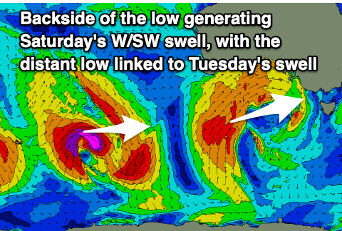 Due to the evolution of the low, we're only expected to see some small, inconsistent side-band energy building through Friday, with the best pulse in size due Saturday from the fetch tomorrow.
If on the Surf Coast keep your expectations lowered and be happy with any sort of surfable runner. Infrequent sets to 2ft+ may be seen into the afternoon Friday, 4ft on the sets to the east along with gusty N tending N/NW winds. This will open up options to the east across selected breaks.
Into Saturday the better swell should offer 2-3ft waves on the Surf Coast 4-5ft to the east and with stronger N/NW winds as the low nears closer to us.
Come Sunday the low will move across us bringing gusty W/NW tending W winds but with no real decent follow up swell.
Weak windswelly surf is expected on Sunday, easing from 2-3ft max on the Surf Coast and 4-5ft to the east.
The models are over-forecasting this whole swell so again, keep your expectations low.
 Moving into next week we've got some much more reliable swell sources on the cards later in the week, but before this arrives, some small, inconsistent long-period swell is due later Monday and Tuesday. This will be generated by a strong but poorly structured polar low with a limited swell generating fetch (image above). Expect inconsistent 2ft waves on the Surf Coast and 3-4ft sets to the east on Tuesday along with N/NE winds.
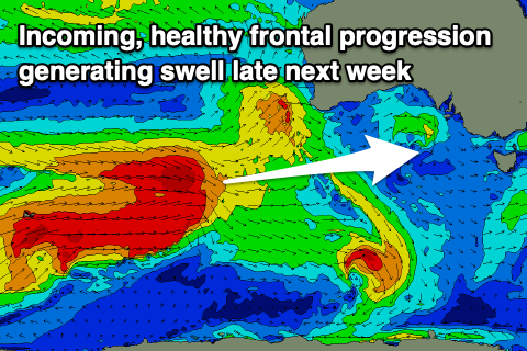
Of greater significance is a stronger frontal progression firing up to the south-west of Western Australia later in the weekend and early next week, generating a moderate sized + W/SW groundswell for later week but we'll go over this in more detail on Friday.
Comments
Will be lucky if wave face is bigger then 2 foot with such a west swell and I don't need a swellnet subscription to out predict swellnets forecast
Magnets are already above your forecast and today is the worst of the incoming energy.
We've got the best swell still due tomorrow.
Guy on a shoulder high runner.
Hahah got him
Think it's because Poo Man exclusively surfs Fishos.
Wow even the freak sets are way under sized of the predicted 1.7m
Thursday next week looks of interest to me.It is " The Queen is Dead "
public holiday so expect some crowds braving the nippy brine,all looking for a wave.
She said I know you and you cannot surf etc…
An hour in from a surf on a not so secret beachy. 2 ft runners, only me and a mate super clean. Sick fun. Now full of pizza and beer waiting for the footy. Life's good.
Know that feeling well…nothing better. Would love a bit more swell but these small clean fun days are still a heap of fun.
Was told urbnsurf have just jacked up their prices again, $100 to surf the tub these days. Hard to justify forking that out for an hour