Plenty of options over the coming days

Victorian Surf Forecast by Craig Brokensha (issued Monday 12th September)
Best Days: Tomorrow morning, Wednesday exposed beaches, keen surfers with low expecations Surf Coast Friday afternoon and Saturday, Sunday Surf Coast
Features of the Forecast (tl;dr)
- Large, reinforcing S/SW groundswell for tomorrow AM, easing steadily and much smaller Wed
- Variable tending SE winds tomorrow (likely locally offshore across most spots in the AM)
- Strengthening N/NE winds Wed
- Small, flukey W/SW swell building Fri PM, holding Sat with strong N/NW tending NW winds Fri and NW tending W winds Sat
- Mid-period W/SW swell Sun with NW tending W winds ahead of a late SW change
- Plenty of swell next week with favourable winds
Recap
Weak, small surf to start off the weekend with lumpy options on the Surf Coast for the keen. A strong change kicked up a localised swell which cleaned up into Sunday morning with fun, clean 2ft to occasionally 3ft waves on the Surf Coast, bumpy and poor to the east.
Today we've got our large, powerful S/SW groundswell in the water, generated by a strong polar low pushing north-east towards on the weekend.
Winds are now deteriorating as the we start falling under the influence the backside of the polar low, bringing strengthening SW winds.
This week and weekend (Sep 13 - 18)
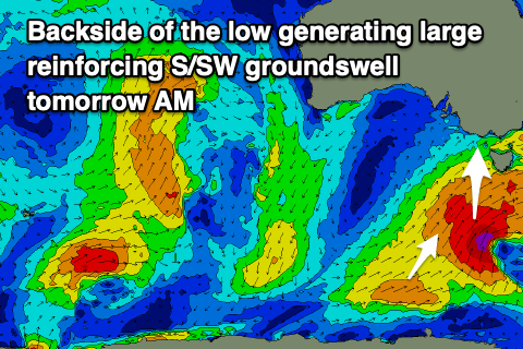 The polar low linked to today's large S/SW groundswell has been slow moving through our swell window and a secondary intensification of of gale to severe-gale S/SW winds to the south-southwest of Tasmania last night.
This should maintain largish surf into tomorrow morning across the Surf Coast and Mornington Peninsula before easing steadily into the afternoon, further Wednesday. Winds are looking more favourable than they were on Friday last week with a light, variable winds due across all locations, likely tending locally offshore ahead of SE sea breezes.
Easing sets from 4-6ft are due on the Surf Coast, 6ft+ to the east, dropping steadily during the day and then back from 3ft on the sets Wednesday morning on the Surf Coast magnets, 3-4ft to the east.
Strengthening N/NE winds will favour the exposed beaches on Wednesday, best before lunch with the swell bottoming out on Thursday.
The rapid improvement in winds across the state is linked to a strong high moving in from the west but this will also block our main swell windows resulting in slow surf ahead of some tricky W'ly swell into the weekend.
The source of this swell will be another mid-latitude low forming south of Western Australia, meandering slowly east through the Bight but with quite a bit of strength.
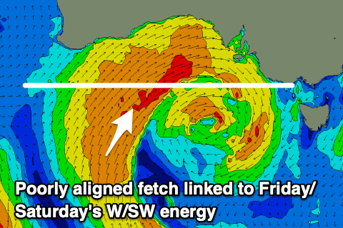 Besides the early stages of the formation of the low, where we'll see some weak, distant W/SW winds aimed through our swell window, the whole evolution of the low looks to be too far north of our swell window resulting in no real considerable size at all for the Victorian region.
If the low tracks a touch further south we can expect some fun swell Friday/Saturday but at this stage the models aren't resolving the energy very well and over-forecasting the size through Bass Strait.
At a maximum 2-3ft sets are due on the Surf Coast magnets Friday afternoon and Saturday, more likely 3-5ft to the east and with strengthening N/NW tending NW winds on the former, NW tending W on Saturday as the low moves across us.
As the low moves across us on the weekend it's expected to bring some mid-period W/SW energy for Sunday that looks to be more to 3ft on the Surf Coast and 4-5ft to the east along with strong NW tending W winds ahead of a late SW change.
Longer term the outlook is promising with back up frontal systems expected to generate moderate sized pulses of swell through next week with favourable winds. More on this Wednesday.
Comments
Bet tomorrow will die in the ass hard. Look good before work. Look shite after work.
Unfortunately yes it will.
Take the day off Bone. The left to the right of the enterprise, and the right to the right of the left to the right of the enterprise and the left off the right that’s to the right of the left that’s to the right of the enterprise all have sand to remember. Need some carpentry skill on the rebuild of the rangers demolition shack too. Tomorrow would be a good day for a surf and a working bee.
Had a bit of fun there last week. 4 out and then all came in. Went on to sing a few nursery rhymes on Friday but needed the big notes.
Ahhhhh the old smack shack. The injection room with ocean views. Fucking ludicrous idiots.
Haha, still have the footage of those fools and their chainsaws.
PS looking much better on the Peninsula now. That variable offie has kicked in.
That low is hitting us now over in the West, it's decent. And quite north in where it's formed.
Why do you always get 10 wave sets when it’s a shade too big but struggle at to get consistency at 3ft?