Not much surf, lots of snow potential

Victorian Surf Forecast by Craig Brokensha (issued Monday 23rd May)
Best Days: Today on the beaches, exposed beaches tomorrow and Wednesday, later Friday exposed beaches, Saturday, Sunday morning Surf Coast afternoon east of Melbourne, east of Melbourne Monday
Features of the Forecast (tl;dr)
- Small, inconsistent surf over the coming days with favourable winds for the beaches
- Inconsistent, mid-period SW swell building later Fri, peaking Sat AM with local offshore tending variable winds
- Inconsistent mid-period SW swell Sat PM, holding Sun with NW tending N/NE winds
- Easing SW swell Mon with N/NE winds
- Poor, stormy SW swell next Tue with SW winds
Recap
The swell continued to tail away into Saturday, further Sunday morning as light winds favoured the beaches. A new pulse of inconsistent SW groundswell arrived into the afternoon and this has held into this morning with better 4ft sets on the exposed beaches to the east, 2ft on the Surf Coast.

This week and next (May 24 - Jun 3)
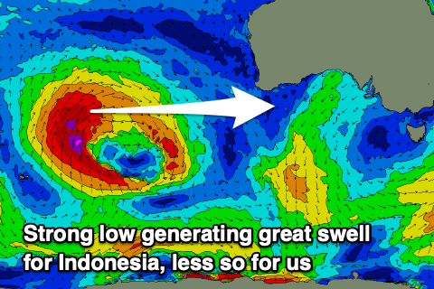 It's good to be back behind the forecasting desk, but heading into the final week of May, the outlook is for a slow period as a large, blocking high moves slowly east. There's been no significant polar frontal activity on the southern or south-west flank of the high and a strong mid-latitude storm firing up in the Indian Ocean was too far north to generate any swell for us.
There might a tiny hint of inconsistent W'ly groundswell to the east on Wednesday but generally we'll see the Surf Coast ease back from 1-1.5ft tomorrow with easing 3ft sets on the Mornington Peninsula, with Wednesday looking to come in at 1ft (Surf Coast) and 2ft to possibly 3ft respectively.
Winds will favour the beaches over the coming days with a N/NE offshore, tending E/SE mid-late afternoon tomorrow, and all day offshore N/NE tending E/NE-NE winds on Wednesday.
Thursday looks smallest and a lay day with stronger N/NE winds ahead of a weak low and weaker W/NW breezes Friday but with no considerable increase in size.
Later in the afternoon and more so Saturday we should see some new, mid-period SW swell, followed by a stronger kick into Saturday afternoon.
The source of these swells will be a poorly structured and distant polar low that's currently sitting over and just east of the Heard Island region.
A patchy fetch of strong to gale-force W/NW-NW winds will generate the increase in size later Friday and Saturday morning, with weaker trailing W/SW winds producing the slightly better but weaker swell for Saturday afternoon and Sunday morning.
Inconsistent sets to 2ft to occasionally 3ft are due on the Surf Coast magnets Saturday morning, 4ft+ to the east with the secondary pulse coming in at a more consistent 2-3ft and 3-5ft to the east.
Conditions look favourable for both coasts on Saturday as the weak low moving through weakens further ahead of another weak front, bringing light N/NW offshore winds on the Surf Coast, N/NE to the east and variable into the afternoon.
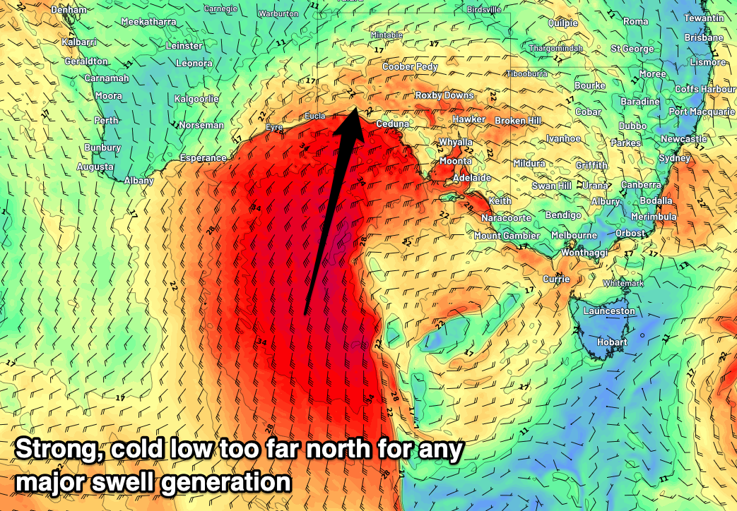 NW winds will then favour the Surf Coast Sunday morning, possibly shifting N/NE into the afternoon as a broad and significant low pressure system forms high in the Bight and starts to move in from the west.
This low unfortunately looks poor for swell generation but great for snow generation with it pushing too far north of us, directing gale to severe-gale S/SW winds up into South Australia with no real favourable fetch aimed in our direction.
The low will bring N/NE winds on Monday favouring the exposed beaches ahead of a strong SW change on Tuesday and an increase in poor, localised windswell.
Following this though we've got a better swell generator on the cards for late week, but more on this Wednesday.
Comments
crap it's lucky we had last week to satisfy the craving. Welcome back and I Hope Ben is feeling more upbeat after last weeks forecasted swell came a few hours later than he predicted and the whingers got on his case, what a terrible unforgivable thing to do :). (See my comment from last Wed)
PLStocks. I’m with you brother, the audacity of some idiots hey, swell doesn’t arrive on tee like a bus timetable, its a ‘predicted forecast’. All those whinging nuff nuffs should sincerely apologise, but after all, in our little privileged society, its simply just a 1st World problem. Use your brain, i loaded the Ute with a 6’10” in anticipation of what might be, turned out it wasn’t, and had a back 6’2” if it was smaller, totally sorted, ultimately surfed 4-6ft clean waves at first light with 6 dudes out, great session without all the stormtroopers and Super Heroes.
Welcome back Craigos! Might need to put Benny on stress leave after last week
Haha
Hey just a question is the forecast data currently up accurate? Despite long term forecast not up! Just packing for Indo and choosing boards !
It's being updated as we speak, a couple of days behind but should be up to scratch this evening hopefully.