Good end to the week with an improvement in the wind forecast

Victorian Surf Forecast by Craig Brokensha (issued Wednesday 22nd December)
Best Days: Today, tomorrow, Friday morning on the beaches, Wednesday morning for the keen on the beaches, next Thursday morning
Features of the Forecast (tl;dr)
- Mod-large mix of SW swells easing tomorrow with light S/SE winds (variable across most locations), increasing to moderate through the PM
- Further drop in energy Fri with E/NE tending fresh SE Winds
- Low point in swell Sat with moderate S/SW winds, strengthening late PM
- Poor S windswell Sun with strong S winds
- Mod sized mid-period S/SW swell Mon AM with mod-fresh SE winds, strengthening through the day
- Easing S/SW swell Tue with fresh E/SE tending SE winds
- Small SE windswell Mon PM and Tue
- Easing surf Wed with E/NE tending S/SE winds
- Mod sized S/SW groundswell building Wed PM, easing Thu with variable tending S/SE winds
Recap
Monday's pulse of good sized swell eased off a touch into yesterday morning with slower 4ft sets on the Surf Coast magnets, 3ft across most other breaks. The exposed beaches to the east were still solid but bumpy with the onshore breeze. Conditions improved to the east into the afternoon as winds tended variable while the Torquay region saw sea breezes deteriorating conditions from late morning.
Today our larger mix of mid-period and groundswell energy are filling in with the Surf Coast reefs offer 4-5ft waves with early light winds and some slight lump/bump. The beaches to the east are big and protected spots are the go. Winds will shift S/SW through the day but only moderate in strength as the swell builds further, reaching 4-6ft on the Surf Coast and 6-8ft to the east.

Good sized sets this morning
This week and next (Dec 23 - 31)
The large surf filling in across the state today will peak this afternoon/evening only ease slowly into tomorrow owing to the longevity of the frontal progression and polar low linked to all the activity.
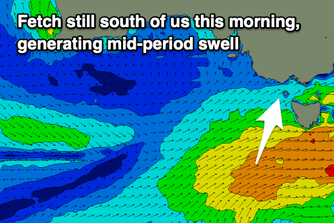 The least consistent and stronger groundswell energy sets from the initial polar low (south-west of Western Australia on the weekend) are due into this afternoon, while we'll see mid-period energy continuing to provide consistent large sets as well.
Both will ease tomorrow but the Surf Coast should still be around 4-5ft in the morning with 6ft to possibly 8ft sets on the Mornington Peninsula.
Winds are now looking more favourable tomorrow with a very light S/SE breeze, likely variable across the Surf Coast in the morning with lumpy, decent conditions. Winds will slowly increase through the day but not get too strong, creating good waves for most of the day.
Friday morning is looking better as well with a light E/NE offshore and plenty of size for the beaches. The Surf Coast looks to be still around 3ft, but easing more noticeably through the day with 4-5ft sets to the east. Get in through the morning before fresh SE sea breezes kick in.
Unfortunately there's no change to the weekend's outlook with the surf due to reach a low point on Saturday along with strengthening S/SW winds (more so late afternoon, moderate in the morning). This will be as a high pressure system moves in from the west, with strong S'ly winds due to persist into Sunday, bringing a weak, small S'ly windswell.
We should see some new, mid-period S/SW swell building through Sunday afternoon, but peaking Monday morning, generated by a relatively weak but multi-staged polar frontal progression developing south-west of us Friday.
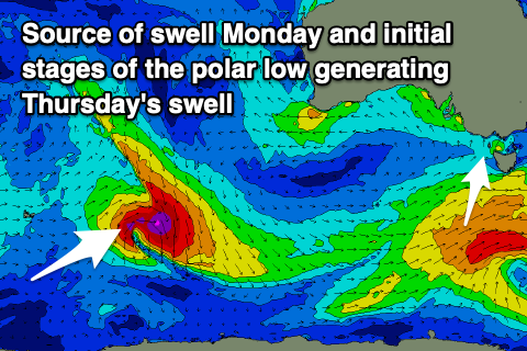 Fetches of strong to near gale-force W/SW winds will be generated through our south-western then southern swell windows, with the Surf Coast due to offer 3ft+ waves with 4-5ft sets to the east.
Unfortunately a deepening surface trough off the East Coast will squeeze the high to our west, bringing strengthening SE winds on Monday, persisting from the E/SE Tuesday as the swell eases. This will kick up some small, weak SE windswell for the Surf Coast.
Wednesday morning looks cleaner under an E/NE breeze but with a low point in swell.
A strong polar low is due to generate a fun S/SW groundswell for later Wednesday, easing Thursday with what looks to be light, variable winds. More on this Friday.
Comments
Cheers Craig, been a fun few days. Have a ripper Christmas mate
Yeah looks it! You too Dx3!
Yep it's been fun, some good backhand whacks here.
Surf Coast Times is reporting our coast is now the 'Smart Coast' - more qualifications than any other shire in Vic, including Melbourne. Smart enough to realise that being on the coast and just going surfing is by no means a waste of intellect, ha!