Great run of swell next week

South Australian Forecast by Craig Brokensha (issued Friday May 2nd)
Best Days: Tomorrow South Coast, Monday, dawn Tuesday Mid Coast, South Coast Tuesday, both coasts Thursday, South Coast Friday
Features of the Forecast (tl;dr)
- Inconsistent S/SW groundswell tomorrow AM, easing, tiny Sun
- Fresh N/NE-N tending weaker N/NW winds Sat, freshening N/NE tending N/NW winds Sun
- Large W/SW groundswell building rapidly Mon, peaking into the PM with mod-fresh N tending N/NW winds, easing later (N/NE early Mid Coast)
- Slightly smaller reinforcing W/SW swell Tue with NW tending fresh W/NW winds (likely variable dawn Mid Coast)
- Large SW groundswell building Wed, peaking in the PM, easing slowly Thu
- Fresh W/SW-SW winds Wed, light, local offshore Thu AM, tending N/NW-W/NW
- Easing surf Fri with N/NE tending variable winds
Recap
The Mid Coast continued in the tiny range yesterday and today with 1ft waves that pulse a little depending on the tide. The South Coast was raw and lumpy but improved slightly through yesterday morning with some localised S/SE windswell, much better today with small, clean waves to 2ft+ across Middleton.
Sea breezes will kick in this afternoon so surf now.
This weekend and next week (May 3 - 9)
While a small lift in mid-period SW swell is expected this afternoon, a better but short-lived S/SW groundswell should be in the water tomorrow morning. The source of both of these swells was a strengthening frontal system come polar low, tracking south-east towards the polar shelf while intensifying.
A fetch of severe-gale W’ly winds should produce inconsistent 2ft to occasionally 3ft waves off Middleton, easing through the day, then tiny Sunday.
Conditions will be great all day tomorrow down South with a gusty N/NE-N tending weaker N/NW breeze, with Sunday seeing freshening N/NE tending N/NW winds.
Moving into next week and we’ve got multiple pulses of large westerly shifting south-westerly swell inbound, owing to a strong node of the Long Wave Trough strengthening across Western Australia, then moving eastwards.

This is steering a strong polar frontal system up and towards that state, with a great fetch of severe-gale to storm-force W/SW winds being generated through our western swell window.
This will produce a large W/SW groundswell for Monday, with the Mid Coast likely being solid from early while the South Coast might peak a little later in the afternoon.
A secondary mid-latitude frontal system pushing in under the Bight through Sunday, will then produce a reinforcing, slightly smaller pulse of swell for Tuesday.
Size wise the Mid Coast is still looking to come in at a consistent 3ft with 4ft waves on the favourable parts of the tide Monday with the South Coast building to 4-5ft+ off Middleton.
Local winds still look great for the South Coast Monday with a moderate to fresh N’ly tending N/NW breeze, easing off later, with the Mid seeing early N/NE breeze, though bumpy all day.
As the reinforcing swell moves in Tuesday, it should maintain 2-3ft surf on the Mid Coast with easing waves from 4-5ft down South across Middleton and a NW tending fresher W/NW will favour the South Coast again with a period of dawn variable winds likely on the Mid Coast.
Into Wednesday/Thursday, a larger reinforcing SW groundswell is due, generated by tertiary frontal activity moving in, under the country Tuesday.
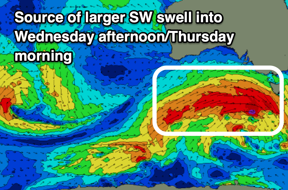
This looks to produce a broad fetch of gale to severe-gale W/SW winds further south in latitude, more favourably aligned in the South Coast’s swell window and with this we’re expecting a large pulse through the day to an easy 6ft across Middleton with the Mid Coast continuing around 2-3ft, easing from a similar if not slightly smaller size come Thursday morning.
From Friday onwards the easing trend looks more noticeable though an active trailing fetch of activity will continue to supply the South Coast with plenty of energy into Saturday, likely still 3-4ft.
Looking at the local winds, Wednesday will see fresh W/SW-SW winds, with only an outside chance of early W/NW winds around Victor, with Thursday coming in much better under variable offshore winds that then look to freshen from the N/NW tending W/NW.
Friday is tricky but the South Coast looks to remain clean, but we’ll look at this closer Monday. Have a great weekend!
Comments
Seaweed was absolutely horrid along the Middleton stretch today (Friday)