Fun tomorrow, with increasing activity next week

Southern Tasmanian Forecast by Craig Brokensha (issued Friday May 2nd)
Best Days: Tomorrow, Wednesday, Thursday, Friday
Features of the Forecast (tl;dr)
- Good S/SW groundswell for early tomorrow, easing steadily, tiny Sun
- Moderate N/NW tending N/NE winds tomorrow
- Fresh N-N/NE winds Sun
- Small, inconsistent W/SW groundswell for later Mon but more so Tue AM with strong N winds Mon, N/NW Tue
- Moderate sized W/SW groundswell building Wed, peaking in the PM, holding Thu AM, easing
- Strong W/NW-NW winds Wed, N/NW Thu
Recap
The swell dropped to the tiny range yesterday, while today we’re seeing some new life in the water with clean conditions and building surf.
This weekend and next week (May 3 - 9)
Today’s building mid-period SW swell should be upped by a slightly stronger S/SW groundswell early tomorrow, easing off steadily through the day.

The source was a south-east tracking polar frontal progression, with a fetch of W/NW-NW gales generating today’s increase, while a slightly stronger and more favourably aligned fetch of severe-gale W’ly winds at the backside of the system will generate early tomorrow’s swell.
Sets to 3ft are due across Clifton, easing steadily through the day with Sunday coming in tiny.
Local winds look great all day tomorrow and moderate from the N/NW tending N/NE with fresher N-N/NE winds blowing all day.
Moving into next week and we’re expected to see some tricky, inconsistent W’ly groundswell arriving across our region, with a strong node of the Long Wave Trough due to move east from a position across Western Australia, bringing with it a flurry of mid-latitude frontal activity.
An initial, distant and strong polar low has projected towards Western Australia, with fetches of severe-gale to storm-force W/SW winds generating an inconsistent groundswell for later Monday but more so Tuesday to 2ft across Clifton.
Strong N winds are due all day Monday with N/NW breezes Tuesday.
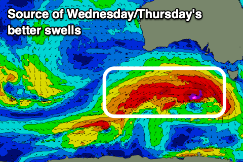
Into Wednesday/Thursday a larger more consistent and reliable swell is due, generated by a great, more southerly positioned frontal progression, with fetches of gale to severe-gale W’ly winds due to bring an increase to 3ft Wednesday afternoon, easing from a similar size Thursday morning.
The easing trend then looks to be slowed by further activity but we’ll have a closer look at this next week. Local winds will remain favourable with a strong W/NW-NW breeze Wednesday as the progression moves across us, great Thursday with all day N/NW winds. Have a great weekend!
Comments
lookin good tomorrow how the cams looking :)
Back next week.. thanks for your patience.