Dynamic period with varying winds and instability

Victorian Surf Forecast by Craig Brokensha (issued Friday 15th October)
Best Days: Today Surf Coast ahead of the change, Sunday Surf Coast, Monday morning Surf Coast, beaches Wednesday for the keen
Features of the Forecast (tl;dr)
- Mix of inconsistent SW groundswell and S/SW windswell tomorrow with strong SW winds
- Easing mix of swells Sun with W/NW winds, tending S'ly mid-late PM
- Building S/SW groundswell Mon with variable W/NW tending SW winds late AM, stronger into the PM
- Easing S/SW swell Tue with SE winds, strengthening later
- SE windswell for Wed, easing through the day with fresh E/NE tending E/SE winds
Recap
Yesterday's new, inconsistent W/SW groundswell was a little delayed in its arrival, but with the morning high tide there was no rush. Conditions were clean on the Surf Coast and favourable to the east, with the swell slowly building through the morning and coming in at 2-3ft through the afternoon on the Surf Coast and 4ft+ to the east. A little under the expected size, and this marries up with the delayed arrival, as if it had more period it would have arrived earlier and had a bit more energy.
This morning we've got improving winds ahead of a stronger onshore change later this afternoon, best on the Surf Coast though not great and to 2-3ft, poor and choppy to the east.

The swell finally showing yesterday afternoon
This weekend and next week (Oct 16 - 22)
The current funky and volatile weather is linked to a slow moving mid-latitude low moving in from the west, drawing in moisture from the east and north-east and cold air from the south.
We're seeing this low push in from the west today, and winds are now due to hold from the W/NW into the mid-afternoon, shifting stronger SW towards the evening. This will favour the Surf Coast as the swell slowly eases.
Come tomorrow we'll be under the influence of the backside of the low with strong SW winds and poor conditions along with a mix of new, inconsistent SW groundswell and localised windswell.
The groundswell has been generated by a strong but distant polar low earlier this week around and east of the Heard Island region. Infrequent 3ft+ sets are due from this source on the Surf Coast, 4-5ft+ to the east, but the localised windswell looks a bit bigger and to 3-4ft and 5-6ft respectively.
The low will continue east on Sunday, allowing winds to swing back to the W/NW on the Surf Coast through the morning along with a mix of easing swells from 3ft+ range. Winds look to hold until mid-afternoon ahead of a shallow S'ly change, so there should be plenty of opportunity to get a fun wave in.
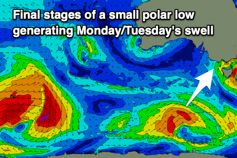 Monday morning should see variable W/NW winds but a trough will bring a SW change late morning which will strengthen through the afternoon. A new S/SW groundswell is due to arrive shortly after dawn, peaking into the afternoon. The source of this is a small, short-lived polar low firing up south of Western Australia today, generating a tight fetch of W/SW gales through our swell window while tracking east.
It looks to offer fun sets to 3ft when it peaks through the day (Monday) on the Surf Coast but with that developing change, 4-5ft to the east.
Unfortunately the trough will take a little longer to clear and actually feed into a deepening mid-latitude low Tuesday/Wednesday. This will leave SE winds on Tuesday as the swell eases from 2-3ft and 4ft respectively across the Surf Coast and Mornington Peninsula.
Stronger E/SE winds overnight Tuesday looks to generate a SE windswell for Wednesday as winds tip back to the E/NE. This will create clean conditions on the Mornington Peninsula but there'll be no quality groundswell with peaky 2ft sets. Following this the outlook remains slow (besides a possible W/SW groundswell next weekend) so make the most of the coming windows of favourable conditions. Have a great weekend!
Comments
Deceptive lefts at Torquay this AM.
Very deceptive indeed! Craigos away again Benny?
Yep, forecast will be up around 5pm.