Make the most of the coming period ahead of a slower outlook

Victorian Surf Forecast by Craig Brokensha (issued Friday 8th September)
Best Days: Today, protected spots tomorrow and Sunday, Tuesday east of Melbourne (possibly Surf Coast as well - check back Monday), Wednesday and Thursday exposed beaches
Features of the Forecast (tl;dr)
- Easing mid-period SW swell tomorrow with strong N/NW tending W/NW winds
- Low point in swell Sun AM, ahead of building mid-period W/SW swell energy into the PM. Strong W/NW-NW winds, tending W late
- Peak in W/SW groundswell Mon with strong but easing S/SE tending S winds
- Easing W/SW groundswell Tue with light S winds on the Surf Coast, light N/NE to the east
- Small, S/SW groundswell Wed with E/NE tending S/SE winds, easing Thu with N/NE winds
Recap
After a pumping day of surf Wednesday, yesterday was still really fun with easing 3-4ft waves on the Surf Coast, 5-6ft to the east and surprisingly clean to the east before deteriorating through the day. The Surf Coast was also best early with the wind really killing things off into the afternoon (though still offshore)
Today we've got clean though slightly lumpy waves across the Surf Coast but with some new mid-period swell energy to 3-4ft, with bumpy, 4-6ft waves to the east. We should see the swell strengthen further through the day as winds swing more N/NW on the Surf Coast (then variable into the afternoon), with N/NE-NE winds to the east.
This weekend and next week (Sep 11 - 17)
Today's mid-period SW swell has fileld in nicely and we should see a peak through the day which will produce the odd bigger set over 3-4ft on the Surf Coast swell magnets and to a more consistent 6ft on the Mornington Peninsula, with possibly bigger sneakers.
Winds will improve for the beaches into the afternoon, tending light N/NE-NE while the Surf Coast should see variable N/NW winds. All in all it should be a fun, full day of waves today.
 Into tomorrow, the swell will ease, dropping from 3ft to possibly 4ft on the Surf Coast magnets and 4-5ft+ to the east. There might be a slim window of OK conditions across exposed spots to the east with a strong N-N/NW breeze at dawn but this will swing W/NW through the late morning and hold into the afternoon, favouring the Surf Coast.
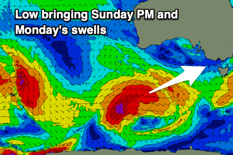
A low point in swell is due Sunday morning, but some new mid-period W/SW swell is due to arrive late morning, building through the afternoon ahead of a stronger groundswell on Monday.
The source of this swell is a strong polar low that's currently south-southwest of Western Australia, generating a great fetch of severe-gale SW winds. The low will project north-east through our western swell window while slowly weakening and then pushing up into South Australia.
This projection into South Australia will allow us to see a longer period of workable, though strong W/NW-NW winds on Sunday, shifting W'ly late afternoon ahead of a S'ly change early Monday.
Swell wise, mid-period energy will build ahead of the groundswell with the Surf Coast due to build from 2ft+ to 3-4ft into the afternoon with the Mornington Peninsula building from 4ft to 6ft into the afternoon.
Monday will unfortunately see those strong, but easing S/SE tending S winds as the groundswell peaks, with 4-5ft+ waves due on the Surf Coast, 6-8ft to the east.
Come Tuesday, winds are looking a little tricky and we might need to reassess this on Monday but a trough may see lingering though light S'ly winds on the Surf Coast, N/NE to the east in the morning. This will be with easing surf from 3ft+ on the Surf Coast, 4-5ft to the east.
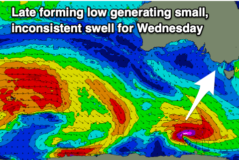 Winds will slowly improve and swing E/NE on Wednesday and NE on Thursday as a strong high moves slowly east under us mid-late week. A small, new S/SW groundswell should provide fun waves for the exposed beaches, generated by a small, tight low firing up late in our swell window Sunday evening, to the south-west of Tasmania.
The late formation and slim nature of the swell producing fetch is a little worrying, but we should see infrequent 2ft sets on the Surf Coast, 3ft to possibly 4ft to the east on Wednesday, fading Thursday with those N/NE winds. It's worth noting the models are incorrectly combining the new groundswell with mid-period energy on Wednesday and Thursday, over-forecasting the size.
Friday will be clean on the beaches again but small to tiny.
Following the recent run of good swell and conditions, we've got a run of smaller surf as the high mid-late next week blocks our main swell windows, while a slow moving mid-latitude low firing up off Western Australia won't generate any swell for us, but also blocks any close-range swells being generated. Therefore make the most of today and the coming days. Have a great weekend!
Comments
Geez there was a chunk or two this arvo. Saw a righteous cleanup set of a whole lineup.
Yeah looked solid on the cams!
Biggest 3-4 ft I’ve seen! Love it
Yeah that fetch wasn't even that strong but has punched well above :/
A solid 6' and absolutely pumping at the halfway point at 13th. The bombie also getting a good look at with a tow crew hooking into some solid walls. Towns getting very packed as lockdown is done but the solid swell leaving the lineup to just familiar faces. Hope you SC crew scored as well late arvo!!
Although it was quite wonky needed a good offshore
Yeh was wonky all day, especially the early, but really packed a punch this arvo, had a great after lunch session.
Ew sounds like queensland just before a sea breeze
Still some decent sets today as well. What a swell
Long term prospects look decent.