Solid, windy swells ahoy!

Victorian Surf Forecast by Ben Matson (issued Wednesday 12th May)
Features of the Forecast (tl;dr)
- Windy conditions from Thurs thru' Mon
- Solid swells building Fri, large Sat, then easing Sun
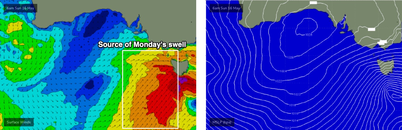
- Another large windy swell Mon, easing Tues with light winds
- Strong surf due next Fri/Sat with light winds
Recap
Strong S/SE winds created terrible surf conditions on Tuesday. Easing swells and a swing in the wind to the east allowed for an improvement east of Melbourne this morning. The Surf Coast was poor early this morning under the sideshore breeze, but has improved this afternoon as the wind became light and variable.
This week (May 13 - 14)
*Today’s Forecaster Notes will be brief as Craig is away*
We’re at the cusp of five days of windy conditions as an amplifying Long Wave Trough steers a succession of vigorous cold fronts into the Victorian coastline.
Thursday will start off small with strengthening NW winds, swinging W/SW along the Surf Coast early afternoon (a little later east of Melbourne). We’ll see building size into the afternoon but there won’t be any quality on offer, as sheltered spots will initially be too small. Keen surfer may jag a small blustery wave in Torquay early but it’s not worth too much attention.
Two more fronts are expected to cross Bass Strait on Friday, one in the early hours of the morning and another after dinnertime.
Whilst the synoptic flow between the two will be strong to gale force W/SW, we should see local topographical influences swinging these winds to the W/NW west from Torquay, which should allow for workable though somewhat blustery conditions. East of Melbourne won’t have anything worthwhile.
As for size, the storm track has been riding quite high in the Bight over the last few days so the swell direction will be quite westerly, which will cap surf size in Torquay to a degree. The models are calling 3-5ft surf but I think this may be a fraction optimistic, 3-4ft is probably a better fit for most open locations with bigger sets at the reliable regional swell magnets.
East of Melbourne will be too large and windy at the open beaches, and sheltered spots may be undersized, though winds should be ideal for Western Port. It’ll be worth a look here on the more favourable parts of the tide.
This weekend (May 15 - 16)
Saturday looks to be post-frontal in the wake of Friday night’s change, whilst Sunday will be pre-frontal as another system rears up from the south-west.
As such, Saturday is looking pretty junky at most coasts. We’ll see a lift in size to 4-6ft west of Melbourne but only sheltered spots will offer clean conditions. There’s an outside chance for a brief window of early W/NW winds, but even if this does occur, it may not be enough to iron out the bumps generate overnight Friday.
Saturday should offer reasonable waves at the sheltered spots east of Melbourne, let’s hope the wind stays more west of SW than south.
As for Sunday, surf size will ease from Saturday but winds will head back around to the W/NW which is great for Torquay. By mid-afternoon it’ll probably be back to strong W’lies so make the most of the early session, as size abates from 3-4ft+.
Conditions will be much better for Western Port on Sunday though the easing swell size may start to create borderline opportunities for many locations. Open beaches will still be a write-off.
Next week (May 17 onwards)
Sunday’s late frontal passage (see below) will deliver another strong round of surf, up to 5-6ft+ in Torquay and 8ft east of Melbourne, with a little more S in the SW direction offering a better spread of size throughout the Surf Coast. However, once again we’ll be post-frontal under a gusty SW breeze, with only a slim chance for an early W/NW breeze west of Torquay. So, protected spots will continue to offer the best waves.
Rapidly easing surf is then expected Tues onwards as winds veer lighter NW and gradually freshen through Wednesday and early Thursday. East of Melbourne will only see surfable options on Tuesday with the lighter breeze and a still-decent size for sheltered spots. By Wednesday these locations will probably be too small.
A strong zzonral frontal progression south of WA early next week looks like setting up an excellent W/SW groundswell for Friday and Saturday, and fortunately the storm track looks like it’ll be steered well to the south of Victoria so this next event should be accompanies by lighter winds (in the wake of a vigorous front on Thursday afternoon). More on this in Friday’s update.
Comments
I miss Craig :(
While I'm waiting for the local Notes I noticed a minor typo at the beginning of the 2nd last sentence. (lol)