Fading surf with strengthening offshores, strong swell next week

Victorian Surf Forecast by Craig Brokensha (issued Wednesday 17th)
Best Days: Beaches tomorrow, possibly Saturday morning on the beaches
Features of the Forecast (tl;dr)
- Easing, peaky surf Thu with freshening NE tending N/NE winds ahead of mid-late afternoon sea breezes
- Inconsistent W'ly groundswell Sat with variable tending SW winds
- Moderate to large W/SW groundswell for Mon PM but with strengthening S/SW winds, easing Tue with strong S winds
Recap
Cleaner conditions across all locations yesterday with 2ft to occasionally 3ft sets on the Surf Coast, 4ft to the east, while today we've got a touch more energy in the water with a touch more size breaking on the coast. Conditions are cleanish again on the beaches (some slight lump), a bit ruffled on the reefs.
This week and next (Feb 18 - 26)
Today our inconsistent, mid-period SW swell is peaking across the state and from here, the size and power of the surf will fade into the end of the week.
Easing sets from 3-4ft are expected tomorrow on the Mornington Peninsula, 2ft on the Surf Coast and winds will freshen from the NE tending N/NE, giving into sea breezes mid-late afternoon. There'll also be some peaky SE windswell in the mix from strong E/SE-E winds through Bass Strait, likely the most noticeable signal on the Surf Coast.
Friday's stronger N/NE winds are still expected but there'll be nothing left in the tank, tiny on the Surf Coast and possibly the odd, stray 2ft'er on the Mornington Peninsula.
Moving into the weekend and we've got a window of variable winds Saturday morning, but they look to be biased from the west. This along with a very inconsistent, small W'ly groundswell doesn't bode well for a fun time. GFS has a trough and change delayed, resulting in more favourable N/NE winds, but I find this unlikely (check back one final time Friday).
Size wise the Surf Coast isn't likely to top 1-2ft on the swell magnets, with very inconsistent 3ft to possibly 4ft sets on the Mornington Peninsula.
Sunday will see onshore winds in either case with moderate S/SW breezes winds and a continuation of small, slow surf.
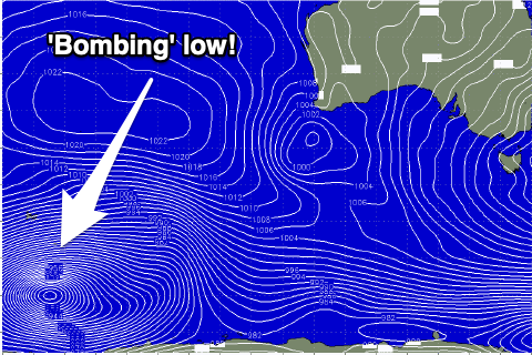 Of greater significance is the stronger, long-period W/SW groundswell due Monday afternoon. This is being generated by a 'bombing' low forming around the Heard Island region last night and today. A 'bombing' low is one which drops 24hPa or more in central pressure over a 24hr period, and we'll see this easily occur, with the central pressure dropping over double that!
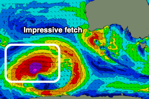
It'll bottom out at 927hPa this evening, with a great fetch of storm-force W/SW winds projected through our far swell window.
The low will weaken slowly while projecting east-northeast towards the country, continuing to generate severe-gale to gale-force W/SW winds through our western swell window.
 Come the weekend the low will be much weaker but persistent with strong W/SW winds being maintained through our western swell window until Sunday evening. This will provide reinforcing levels of mid-period W/SW swell after the groundswell peak.
The long-period energy is due to arrive overnight Sunday, building steadily through Monday ahead of a peak into the afternoon. The Surf Coast should see inconsistent though strong 4-5ft sets on the swell magnets, 6-8ft to the east but winds will be poor throughout the peak of energy as a ridge of high pressure slides in. This will bring strengthening S/SW winds Monday afternoon (possibly W'ly at dawn but this will be before the swell fills in proper), strong S'ly Tuesday. Wednesday doesn't look much better as winds shift SE with the easing mid-period W/SW swell energy.
Into the end of the week winds are due to swing E/NE, favouring the beaches as the swell eases in size and power. More on this and the local winds Friday though.
Comments
What would your thinking be of the cause of that lunchtime Tp spike at Cs Craigonatorrr?
Very, very distant long-period swell from under South Africa, hence I didn't mention.
Craigos, I was questioning your call on winds for Saturday as all the models I look at were pointing to N or NE. I see that's now changed and you were right all along. Boo!
Bingo!