Attention turns to the beaches

Victorian Surf Forecast by Craig Brokensha (issued Wednesday 20th)
Best Days: Exposed beaches tomorrow morning, beaches Saturday and Sunday mornings
Features of the Forecast (tl;dr)
- Steady drop in S/SW swell tomorrow with E/NE tending N/NE winds in the AM
- New SW swell for Sat AM, bigger into the PM with a S/SW groundswell but with variable tending fresher SE winds
- Easing S/SW swell Sun with variable E winds ahead of sea breezes
- Stormy SE windswell late next week
Recap
Chunky, though choppy waves across all locations yesterday morning with a strong onshore wind and 4ft surf on the Surf Coast and waves to 6ft on the Mornington Peninsula. The swell kicked larger into the afternoon though protected spots were the only option.
This morning we’ve got a drop in swell and lighter SE winds across the Surf Coast, creating cleaner conditions with easing sets from the 3-4ft range, still solid on the exposed beaches to the east with lumpy 4-6ft surf.
We'll see the swell ease steadily through today with fresher afternoon SE sea breezes but the beaches to the east should still be OK.
This week and weekend (Jan 21 - 24)
Down, down, down. That's the trend in size following the large kick in size yesterday afternoon from the 'bombing low' forming late in our swell window.
With the low forming late and then quickly pushing east, the easing trend will be quicker than normal, with easing sets from 2ft on the Surf Coast magnets early tomorrow, an infrequent 3ft to the east.
Conditions will be great for the beaches with an E/NE tending N/NE wind through the morning ahead of sea breezes from the SE.
Friday will be a lay day as the swell bottoms out with an early W/NW breeze ahead of strengthen SW tending S/SW breeze.
Later in the day Friday a new SW swell is due to start showing, peaking Saturday, with a secondary, stronger reinforcing S/SW groundswell for later in the day/Sunday morning.
Saturday's swell has been generated by a relatively weak low that developed east of Heard Island earlier this week, with it still generating a fetch of healthy W/NW winds in our swell window, south of WA today.
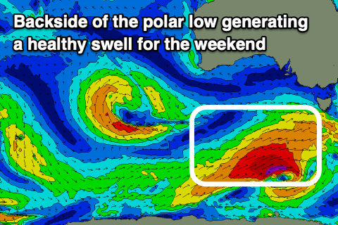 Behind this though, a front come low will generate a pre-frontal fetch of W/NW gales, followed by a better W/SW fetch of gales through our southern swell window Friday.
What we'll see is an initial increase in swell Saturday morning to 2-3ft on the Surf Coast, building later more to 3-4ft, with 4-5ft sets to the east, increasing to 6ft on the sets later. Sunday morning should see easing sets from a similar size, that being 3-4ft on the Surf Coast and 4-6ft to the east.
Looking at the local conditions and winds should ease and tend SE into Saturday morning, becoming variable for a period creating OK conditions for keen surfers before fresher S/SE sea breezes kick in. Sunday then looks more favourable with a variable E/ENE morning breeze ahead of stiff SE sea breezes.
The swells will ease further Monday and there might be a window of fresh N'ly winds at dawn, though these will quickly shift to the NW ahead of a trough.
Longer term there's still nothing of note for next week besides a stormy SE windswell event later as an inland surface trough deepens to our north, drifting across us Friday/Saturday. We'll look at this closer on Friday and in the meantime make the most of the coming surf days.
Comments
Dear Swellnet, Can you do an article on tides. I was looking at tide charts (Bells Beach on Willyweather to be precise) and I noticed something: Between mid-October last year and mid-March this year, the King low tide is somehow never syncing up to be a morning low tide? Lowest in that six month period is a forecast 0.6m and it's always in the neap phase of the tides. That King low somehow only showing in that period in the afternoon/evening. Then looking through the other six months of the year the opposite seems to start to apply, i.e. the huge King low only shows its face in the morning. I know tides vary for reasons other than the moon and I recall an article you did on how much local air pressure can change a forecast tide on any given day. Curious is this pattern I see is just a local quirk or if it is something that happens elsewhere too?