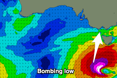
Low currently bombing to our south

Victorian Surf Forecast by Craig Brokensha (issued Monday 18th)
Best Days: Selected spots tomorrow afternoon, beaches Wednesday morning and Thursday morning, Saturday morning protected spots, Sunday morning exposed beaches
Features of the Forecast (tl;dr)
- Large S/SW groundswell building tomorrow but with gusty S'ly winds, improving while easing rapidly Wed
- Cleaner, fun waves on the beaches Thu AM
- New, inconsistent SW groundswell Sat with W/NW tending S/SE winds, best on the beaches Sun AM as the swell eases
Recap
Workable conditions in protected spots for the keen on the weekend with a mix of swells, ahead of a strong kick in new mid-period S/SW swell later yesterday, peaking overnight but still coming in at 3-5ft across the Surf Coast magnets this morning with offshore winds.
This is the best morning of surf for a while and it's worth making the most of before winds shift SW from late morning.
This week and weekend (Jan 19 - 24)
The current swell activity is linked to a strong node of the Long Wave Trough pushing slowly east across us and into the Tasman Sea, dragging up polar frontal activity with it.
 We've already seen three fronts/lows forming under the influence of the LWT, initially in our western swell window, but then moving more into our southern swell window as the node pushes further east, but the strongest of them all (storms) is now forming south-west of Tasmania.
We've now got a 'bombing low' developing just within our swell window, that being the rapid intensification and deepening of central pressure, dropping just over 24hPa in 24 hours.
As the low bombs we'll see a significant fetch of severe-gale S/SW winds generated just within our swell window before the low pushes east, under Tassie. If this development were just a bit more west we'd be looking at very large surf across the state.
In any case, a large S/SW groundswell will be seen from this low, building through tomorrow and peaking into the afternoon to an easy 6ft on the Surf Coast magnets, 8ft on the Mornington Peninsula but with gusty S'ly winds in the wake of today's change.
There'll be options for the savvy but most locations will be poor.
The swell should ease rapidly through Wednesday from 3-4ft at dawn on the Surf Coast, 5ft or so to the east with light to moderate SE winds. The Mornington Peninsula and Phillip Island look to see winds shift E/NE for a period ahead of sea breezes.
Thursday looks cleanest on the beaches with a light NE offshore and easing surf from 2ft on the Surf Coast, and 3ft on the sets to the east, bottoming out Friday as winds shift W ahead of a trough.
As touched on in Friday's update, we've got a small lift in swell for the weekend and with favourable winds. A relatively weak and small polar low will push through our swell window over the coming days, forming east of the Heard Island today. A fetch of strong to sub-galeforce W'ly winds are forecast today and tomorrow, weakening Wednesday, producing an inconsistent swell that should arrive later Friday but peak Saturday with sets to 2-3ft on the Surf Coast and 4-5ft to the east.
A light W/NW breeze will favour protected spots Saturday morning ahead of S/SE sea breezes, best on the beaches Sunday morning with a NE offshore as the swell eases.
Longer term there's nothing significant due into next week besides a possibly stormy E/SE windswell towards the end, but more on this Wednesday.
Comments
Has been a shocka summer thus far Craig good thing I like dirty bikes as it has been nice and cool up the bush. Shite for surf.
A bit of aggro in the crowd yesterday at Lorne Point. Not unexpected given the crowd.