Get stuck in the next two days

Victoria Forecast by Craig Brokensha (issued Monday 16th March)
Best Days: Beaches today until mid-late afternoon, Tuesday, Wednesday AM exposed beaches, protected spots Friday afternoon
Recap
Poor conditions most of the weekend with an easing mix of groundswell and new windswell Saturday with strong onshore winds, improving slightly yesterday morning but still very average.
Today we've got a new pulse of SW groundswell with the Surf Coast seeing stronger lines but bumpy conditions with 3ft sets, 4-6ft to the east and improving as winds swing more offshore. We should see winds go E/NE and then N/NE early afternoon before sea breezes kick in so keep an eye on it.
This week and weekend (Mar 17 - 22)
After an average run of waves the past couple of days, we'll see conditions really clean up and fire across the beaches tomorrow, smaller into Wednesday but still fun.
The SW groundswell filling in today is expected to peak this afternoon/evening, easing thereafter while tending a little more S/SW in direction.
Sets to 3ft are due on the Surf Coast tomorrow morning, 4ft to possibly 5ft to the east, easing through the day under a persistent moderate to fresh N/NE wind east of Melbourne, N/NE likely tending N/NW across the Surf Coast into the mid-late afternoon.
Come Wednesday we're looking at moderate to fresh local offshore winds (N/NW Surf Coast and N/NE-N Mornington Peninsula) as the swell continues to ease. The Surf Coast looks small and to 1-2ft, 2-3ft on the Mornington Peninsula for the keen and easing further through the day.
Thursday looks clean again but with no new swell, bottoming out across the state with local offshore winds again, more NE into the late afternoon ahead of a possible late change.
 This change will be associated with a weak mid-latitude low moving in from the west, swinging winds NW into Friday morning and W/NW-W through the afternoon ahead of a stronger W/SW change.
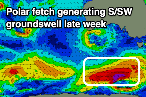
A good new long-period S/SW groundswell will fill in through the afternoon Friday, generated by a strong polar frontal progression firing up south of the country tomorrow afternoon and evening. A great fetch of gale to severe-gale W/SW winds will be generated through our southern swell window, with possible storm-force core winds once positioned south-west of Tasmania.
This is placed ideally through our southern swell window and we should see a good kick in size Friday afternoon to 4ft+ across the Surf Coast late in the day, 6ft to the east. Unfortunately this looks to be with the change, with the morning small to tiny.
Saturday looks a bit average with winds lingering from the S/SW-SW in the wake of the low Friday as the S/SW groundswell eases from 4ft+ and 6ft respectively, fresher onshore Sunday along with a new building S/SW groundswell.
As touched on in Friday's notes, with the LWT strengthening across and the pushing east of us, these swells will be met with those onshore winds instead of it stalling and providing better westerly winds for the Surf Coast.
A constant flurry of strong polar frontal systems will create moderate to possibly large pulses of groundswell but with winds from the southern quadrant, swinging more south-east through mid-next week. More on this Wednesday though.
Comments
Hey Craig, some models have the winds tending more westerly tomorrow morning on the Peninsula. Are you still seeing a more northerly direction?
Looking at the hi-res modelling it looks like we'll see strong N winds at dawn, easing from mid-morning and swinging more N/NE, holding until late afternoon and then possibly S into the evening but light.
About to start one of the great wfh spells of our lifetimes and we got 10+ days of onshore. FFS Huey