Improving surf as the week progresses

Victoria Forecast by Craig Brokensha (issued Monday 9th March)
Best Days: Exposed beaches Wednesday, Thursday, Friday ahead of the change
Recap
Poor and onshore waves across both coasts Saturday with a mix of windswells, a little cleaner on the beaches yesterday but small and weak to 2ft.
Today there's been a slight up tick in background groundswell and better 2-3ft sets on the exposed beaches for keen surfers, but with a bumpy south-east breeze.
This week and weekend (Mar 10 - 15)
We've got an improving week of winds and waves with building swell energy and size before a change moves in late week.
Any swell seen today will drop into tomorrow morning leaving small to tiny waves on the exposed beaches, possibly 2ft or so on the sets, tiny on the Surf Coast.
Winds will be a touch better than today and more E/SE-E but only favouring selected beaches.
Wednesday and Thursday are still looking to be the pick of the week for the exposed beaches (as well as Friday now) with a mix of swells on the way and favourable winds.
The first being an inconsistent, long-range SW groundswell and mid-period mix on Wednesday, generated by a distant polar low that formed around the Heard Island region late last week.
 This swell has filled in across Western Australia today and should arrive late tomorrow on the coast but with sea breezes, peaking Wednesday morning. Also in the mix will be some more consistent mid-period energy from the secondary stages of the low in a much weaker form, pushing east along the polar shelf.
We should see inconsistent 2ft sets on the Surf Coast, with 3-4ft sets on the Mornington Peninsula along with a great offshore NE breeze, possibly tending variable out of the E into the afternoon.
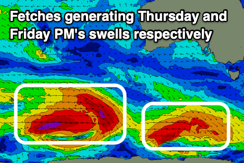
Our secondary pulse of better SW groundswell for Thursday is still on track, with a polar front that's currently south-southwest of WA generating a good pre-frontal fetch of strong W/NW-NW winds, followed by a post-frontal fetch of W/SW gales more in our southern swell window this afternoon and evening.
A touch more size 2ft to possibly 3ft is expected on the Surf Coast swell magnets, 4ft+ to the east and with a great offshore and fresh N/NE breeze, holding all day. The swell should start to ease into the afternoon, smaller Friday morning ahead of a new long-period SW groundswell filling in through the afternoon.
Luckily it looks like an approaching change will be held off until the late afternoon Friday at this stage with a fresh morning N-N/NE breeze due to swing W-SW later afternoon and strong S/SW thereafter.
The source of this new groundswell will be a stronger polar frontal progression forming just east of Heard Island this morning, with a fetch of pre-frontal gale to severe-gale W/NW winds followed by post-frontal severe-gale W/SW winds, weakening south of WA tomorrow evening.
With the storm weakening a fair distance from us we'll see a little less consistency in the swell, but size wise the Surf Coast should build from a small 2ft on the sets early, to 3-4ft on the magnets into the afternoon, 3ft+ to the east, reaching 6ft into the afternoon. The window ahead of the change as the swell builds will be best.
Moving into the weekend and strong onshore S'ly winds will create poor conditions Saturday with a mix of easing groundswell and new windswell, poor and S/SE into Sunday as a strong high moves in from the west.
Longer term average amounts of SE windswell are due into early next week as winds slowly improve, but more on this Wednesday.