Great run for the beaches

Victoria Forecast by Craig Brokensha (issued Monday 30th September)
Best Days: Tuesday morning, exposed beaches Wednesday morning, Thursday, Saturday morning east of Melbourne, Sunday morning exposed beaches
Recap
Building surf with less than ideal conditions on Saturday, better Sunday though not perfect on the Surf Coast with a mix of swells around the 3ft range (a little bigger at some breaks and smaller at others), while locations to the east remained average.
Today our larger SW groundswell has filled in with surf in the 4ft+ range on the Surf Coast, 6ft to the east but with onshore winds.
This week and weekend (Oct 1 - 6)
Over the coming days conditions will improve and today's SW groundswell will gradually ease opening up great options across the more exposed locations around the state.
A light N/NE breeze is due across most locations tomorrow morning, possibly N/NW early on the Surf Coast but there still might be some leftover lump and wobble from today's onshore winds.
Conditions will improve through the morning until E/SE sea breezes kick in and the swell should ease back from 3ft+ on the Surf Coast magnets, 4-5ft to the east on the sets.
Wednesday will be nice and clean across all locations with local offshore winds (N/NW Surf Coast and N/NE Mornington Peninsula) as the swell continues to ease but only to 1-2ft on the Surf Coast and 3ft range to the east, fading through the day.
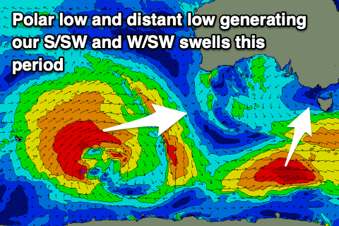 There's been an upgrade of the S/SW groundswell due Thursday, with the polar low linked to it being stronger than forecast late last week. We're now expecting to see a great fetch of polar gale-force W'ly winds generated south-west of Tasmania, in our southern swell window, with the groundswell arriving late Wednesday but peaking Thursday morning to a good 3ft on the Surf Coast and 4-5ft to the east with great offshore N/NE winds, holding into the early afternoon ahead of a SW change.
Come Friday we'll see winds revert back to the W/NW, favouring the Surf Coast though with smaller easing 2ft sets, bumpy and to 3ft+ to the east.
As talked about last update, this weekend we're expected to see an inconsistent long-range W/SW groundswell filling in across the state, generated by a strong, broad and slow moving but distant storm that's currently positioned around Heard Island.
This low is currently generating a broad fetch of severe-gale W/SW winds, and will move slowly east at a similar strength before weakening south-west of WA tomorrow afternoon and evening.
This will result in an inconsistent, and moderate sized W/SW groundswell, arriving later Friday but peaking through Saturday to an inconsistent 3ft+ on the Surf Coast magnets and 4-5ft with 6ft bombs to the east.
Winds are expected to swing right around to the east on Saturday, onshore across the Surf Coast and more E-E/SE than anything, tending E/NE for a period east of Melbourne in the morning.
Sunday morning looks the pick as the groundswell eases from 2-3ft and 4ft+ respectively with a fresh N/NE offshore ahead of a W/NW change as a deepening mid-latitude low moves in from the west.
No major swell is expected in the wake of this low besides a weak mid-period increase in size Monday, but following this we may see strengthening polar fronts projection up and towards us. More on this Wednesday.
Comments
Feather duster under the testicles
Knew you'd like this one NB, ha.
Sqeekiest wheel finally gets some oil..