Improving surf late week, OK weekend for the keen

Victoria Forecast by Craig Brokensha (issued Wednesday 21st August)
Best Days: Surf Coast Friday and Saturday and selected spots to the east, Monday and Wednesday mornings Surf Coast
Recap
Good to great waves in protected spots yesterday with a mix of easing SW groundswell and reinforcing mid-period energy under strengthening W/NW winds, followed today by a large mix of new swells that are coming in at 4-6ft on the Surf Coast and 6-8ft to the east. Early W'ly winds favoured the Surf Coast but have now shifted to the W/SW.
Today’s Forecaster Notes are brought to you by Rip Curl
This week and weekend (Aug 22 - 25)
A strong cold front is currently pushing across the south-east corner of the country and this has generated large pulse of new SW groundswell today.
This swell is due to peak this afternoon across the state, but tomorrow morning will remain large as a secondary small embedded front projects a fetch of SW gales up and into us this evening.
 4-6ft waves should be seen on the Surf Coast tomorrow morning, 6-8ft to the east but conditions will be poor across all locations with a strong SW wind in the wake of the front, easing into the afternoon, creating a slight improvement.
Friday looks much better with offshore NW tending N/NW winds and easing 3-4ft waves on the Surf Coast, 6ft to the east on the sets.
The swell will continue to ease into the weekend and with offshore N/NW winds, and the models are slowly converging regarding the incoming front/trough.
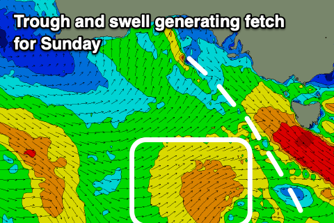
As expected GFS has trended towards EC which will see no real major swell into Sunday as a weaker surface trough moves in from the west, aiming a fetch of strong SW winds through our swell window.
An onshore change associated with the trough is only due later afternoon Saturday and surf wise, a steady 2ft to occasionally 3ft wave is due on the Surf Coast and waves in the 4ft+ range to the east.
The swell for Sunday looks to bump wave heights slightly to a more consistent 3ft on the Surf Coast and 4-5ft to the east but with lingering onshore S/SW winds in the wake of the trough.
Looking at the outlook for next week, and Sunday's swell will ease into Monday with better conditions under a morning W/NW breeze, while some fun new long-range and medium-range W/SW and SW swells are due into the middle of the week.
The long-range energy will be generated by a strong but distant polar frontal progression that's currently formed south of South Africa and will continue east across the Heard Island region and weaken south-west of WA.
The remnants of this progression will continue east under the country through the weekend, strengthening a little south-west of us on Sunday evening.
A fun pulse of mid-period SW swell is due later Tuesday but more so Wednesday, mixed in with the very inconsistent long-range W/SW groundswell. Size wise waves to mostly 3ft, with the rare 4ft'er are due on the Surf Coast magnets, 4-5ft with 6ft cleanups to the east with morning W/NW breezes. A surface trough may bring onshore winds Thursday, but this is a long way down the track.
Comments
Fairly gutless swell (the mid periods you love up there, ha, ha) last weekend Craig and super peaky but nice sunny day and glassy. Howling wind this Saturday before the change and will it be more 4 footers than clean up 6 footers?
Haha, I got to enjoy some great lined up Southern Ocean swell last Thursday back home, though we've got punch back in Sydney ATM. Yeah Saturday looks on the smaller 4ft side of things.