Wave model struggles to resolve incoming swells

Victoria Forecast by Craig Brokensha (issued Friday 16th August)
Best Days: Saturday, early Sunday exposed beaches, Surf Coast Monday, Tuesday and Friday
Recap
Small to tiny waves on the Surf Coast but clean across most spots, with a new inconsistent swell building later in the day, offering sets to a more consistent 2ft. The Mornington Peninsula was bumpy but OK in the morning, better into the afternoon, straightening up and building more to 3ft+.
Today the groundswell has peaked with inconsistent but fun 3ft sets on the Surf Coast, and 3-5ft waves to the east. Winds are starting to shift more NW now ahead of an onshore change due around midday/1pm.

Today’s Forecaster Notes are brought to you by Rip Curl
This weekend and next week (Aug 17 - 23)
Today's inconsistent swell will start to ease slowly through tomorrow, slowed a little through the afternoon as a new inconsistent long-period W/SW groundswell arrives. This was generated by a tight and intense low in our distant swell window and won't provide any additional size.
Easing sets from an inconsistent 2ft to occasionally 3ft are expected on the Surf Coast swell magnets, around the 4ft range to the east. Winds are now looking a little more favourable for a wider variety of locations with variable tending locally offshore breezes in the morning, tending NE through the afternoon and possibly sea breezey in spots.
Strengthening N/NE winds will favour the beaches into Sunday morning with small fading sets from 2-3ft, 1-2ft on the Surf Coast. Winds will shift NW into the afternoon ahead of a strong cold front moving in on Monday.
This system is currently splitting south-west of WA, with a polar fetch of gale to severe-gale W/SW wind starting to take shape.
The polar part of the progression will move slowly east while weakening tomorrow, rejoining with the mid-latitude front that's currently hitting WA and pushing in and across us on Sunday evening.
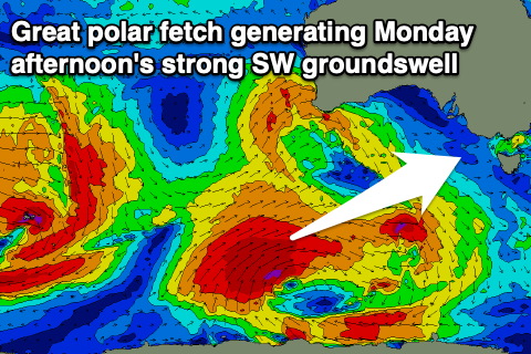 We'll see a mix of weaker mid-period W/SW swell from the front moving across us building Monday, with the larger, stronger, long-period SW groundswell filling in through the morning and peaking into the afternoon.
Our models aren't showing the true size expected off this swell, with the Surf Coast due to build from 3-4ft in the morning to a 4-5ft+ into the afternoon, 6ft to occasionally 8ft on the Mornington Peninsula.
Winds are looking favourable for protected locations all day, fresh to strong from the W/NW as a secondary front pushes up and towards us through the day.
This will produce an additional mid-period W/SW swell for Tuesday as the SW groundswell eases, and opposite to Monday, the models are over-forecasting the size, incorrectly combining the groundswell and windswell.
We're looking at surf to 3-5ft, easing through the day on the Surf Coast and 6ft to possibly 8ft with fresh W/NW tending stronger W'ly winds.
The rest of the week will consistent of moderate to large levels of mid-period swell as further strong cold fronts move in from the west, but fetch strength isn't expected to reach the gale-force range at this stage.
As a result it'll be sizey, but not overly strong in power, mixed in with some smaller and less consistent W/SW groundswell from strong storms in the Indian Ocean.
The models are struggling to resolve these seperate swell sources and over-forecasting the size again mid-late week, with the Surf Coast more likely to come in around 3-5ft Wednesday afternoon through Friday and 6-8ft to the east but with winds slowly deteriorating and swinging strong SW Wednesday with the passing frontal progression, possibly turning into a low off the East Coast Thursday. Friday looks to see cleaner conditions as a high moves in, but more on this Monday. Have a great weekend!
Comments
Craig that long period back up swell is 15.5 seconds. Does that translate into grunty smaller ways mixed with the large sloppy easing swell (at 12 seconds).
Probably similar sized sets to the mid-period energy. The low was quite intense, so tomorrow afternoon could see 3-4ft+ sets on the MP from the source (very inconsistent), but I'm a little sceptical.
I think tomorrow is a fizzler. 3ft sets at best. heaps of people
Yep lots of fizz. "Hope you didnt drive too far" judging by the number of ppl surfing the 2ft slop in 12 degree water this morning I think they are not SN subscribers and they did ha
down the southern end? heard there was 40 people out on Wednesday haha.
Still, I feel like I haven't seen the sun like in agesssssss.
Craigos, on bellsbeach 50 yr storm insta they are saying they are looking at Tuesday 20th and also 27th as possibilities for contest.
They dreamin or what bruz?
Tuesday 20th?? Totally dreaming.. Longer term a bit far out ATM.