Strong swells over the coming days, slow next week

Victoria Forecast by Craig Brokensha (issued Monday 17th June)
Best Days: Surf Coast tomorrow morning, and early Wednesday for keen and experienced surfers, Thursday morning Surf Coast, beaches to the east Sunday and more so Monday
Recap
A great weekend of surf with clean conditions across the Surf Coast and a fun mix of swells, building into Saturday afternoon and easing from a great 3-4ft yesterday morning. Winds tended lighter and more offshore out of the N'th late Saturday on the Mornington Peninsula creating fun, clean waves, easing from a bumpy 4-5ft yesterday morning.
Today the surf has eased off further back to 2ft+ on the Surf Coast and 3-4ft on the Mornington Peninsula under favourable N'ly winds.
Today’s Forecaster Notes are brought to you by Rip Curl
This week and weekend (Jun 18 - 23)
As discussed in this forum thread here, the wave model data is incorrect for the coming few days owing to an update we did over the weekend. With the model starting from scratch, the swells due tomorrow and Wednesday which were generated mostly before the restart are not showing on the charts.
There's been no real change to Friday's forecast for tomorrow's initial pulse of long-period SW groundswell, and then the follow up and slightly larger W/SW groundswell on Wednesday.
Tomorrow's swell is impacting Western Australia today, offering extra-large surf and we'll see it coming in around the medium to large size range through tomorrow. The peak is hard to nail down but the size should be there from dawn with 3-5ft sets due across the Surf Coast swell magnets (inconsistent) and 5-6ft+ to the east. A morning NW breeze will favour protected spots, giving into a SW change later morning.
The secondary swell will have a touch more west to its direction but also a little more size. This was produced by a slower moving fetch of severe-gale W/SW winds, with the storm currently passing under the country in a much weaker form.
Larger 5-6ft sets are due across the Surf Coast swell magnets Wednesday morning with 8ft sets to the east though winds look generally onshore and out of the SW (without too much strength). The Torquay region is likely to see an early W'ly breeze, but don't expect excellent conditions.
The swell is expected to ease later in the day, dropping further Thursday from the 3-4ft range on the Surf Coast and 5-6ft on the Mornington Peninsula. Protected spots will be cleanest with a light to moderate morning W/NW breeze, shifting SW into the afternoon.
Friday and Saturday will be lay days as the swell continues to ease with poor and fresh S/SW winds on the former, S/SE on the later.
 Our next increase in swell will be a very inconsistent long-period and long-range SW groundswell, with it arriving later Saturday and peaking through Sunday.
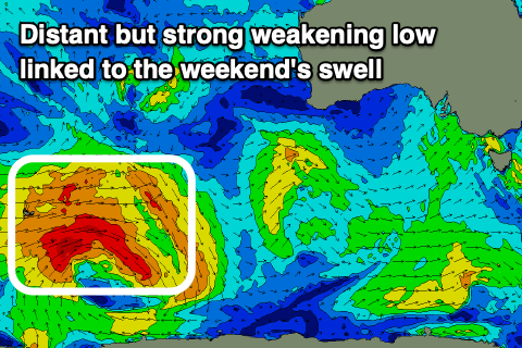
The source of this swell is an intense polar low that's developed south of South Africa and tracked east generating a fetch of severe-gale to storm-force W'ly winds in our far far swell window.
The low is currently around Heard Island and will continue east over the coming days while weakening, breaking down south-southwest of WA on Wednesday. We'll likely see the most consistent size from the later developments, with infrequent bigger set waves every 15-20 minutes as the swell peaks.
In general I think we'll see waves to 3ft on the Surf Coast, with those rare bigger 4ft+ sets, with the Mornington Peninsula more around 4-5ft, with 6ft bombs.
Winds will shift around to the E-E/SE on Sunday creating OK conditions on the beaches, but it won't be perfect. Monday looks better with a N/NE offshore though easing swell.
Longer term there's nothing significant on the cards as large blocking high dominates our immediate swell windows. So make the most of the coming days.
Comments
Unsafe foiling at TQ Point this am.
This guy splitting between two paddlers, no room for error at all!
I'd be telling old mate to go find his own wave away from paddle surfers if I were out..
Paging VL - VL, please report too the enforcer station. Thank you
Torquay Point is precisely the spot to do this type of stuff. The way I see it, the more SUPs, mals, Foils, goat boaters etc surfing the point instead of the other breaks the better.
@bluegums loves hovering around crowded TP
Also re the swell, looks to be a touch delayed from my calculations which were thrown off a little with the wave model outage. Strong signal on the Cape Sorell buoy though and there are good though inconsistent 3-4ft sets now showing on the Surf Coast.
Swell is filling in nicely now..
Seen foilers at TQ point weaving their way through about 30 people. Plenty of close passes. Wont be long until someone needs allot of stitches.
Not sure if you can stitch a head back on but decapitation could be a likely injury.
That's very poor form and selfish!
What are we paying for this month?