Tricky small swell pulses to continue

Victoria Forecast by Craig Brokensha (issued Wednesday 5th June)
Best Days: No great days, keen surfers Friday, Saturday on the beaches, Sunday afternoon exposed beaches
Recap
More onshore and easing S'ly windswell yesterday, a little cleaner this morning but weak and poor.
Today’s Forecaster Notes are brought to you by Rip Curl
This week and weekend (Jun 6 - 9)
The second half of the week is looking a little more promising wind wise, but the swells we'll be surfing are very flukey.
 Firstly an inconsistent new SW groundswell due this afternoon, generated by polar W'ly gales earlier this week should provide small 2ft sets at Surf Coast magnets tomorrow morning, with 3ft to possibly 4ft sets on the Mornington Peninsula.
Winds will be average and fresh from the SW, possibly W/SW early on the Surf Coast, though not worth driving far for.
Into the afternoon a new S/SW groundswell will hopefully start to show, though the source of this swell is a late forming storm south-west of Tassie this morning.
A fetch of gale to severe-gale W'ly winds will be generated just within our swell window, with a tight fetch of severe-gale to storm-force S/SW winds just glancing our swell window before passing into Tasmania's swell shadow.
It's a very tricky swell source, being so late in our swell window, but a pulse of S/SW groundswell should be seen later tomorrow to 2-3ft on the Surf Coast and 4ft to the east, easing back from 2ft to possibly 3ft and 3-4ft respectively Friday morning.
Winds will improve and swing W/NW-NW on the Surf Coast, creating fun small surf for keen surfers, while the beaches should improve after lunch as winds tend more variable and even NE on dark.
Another very flukey long-period S/SW groundswell may be seen on Saturday morning, but this is looking far less reliable. The source of the swell will be a south-east tracking frontal system, generating a great fetch of broad and elongated gale to severe-gale NW winds, but aimed towards Antarctica.
One the storm hits the polar shelf, a burst of severe-gale to storm-force W'ly winds will be generated south-southwest of Tasmania, but this is too far east to generate any decent swell.
 As a result I can't see anything over 1-2ft on the Surf Coast and 3ft on the Mornington Peninsula Saturday morning, easing through the day. Hit the exposed beaches with a persistent N'ly breeze due most of the day, tending unfavourably to the N/NW at times.
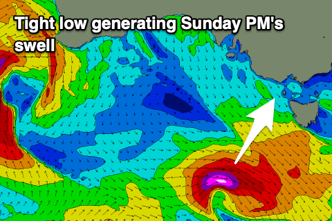
Sunday looks even smaller with a N/NW tending N/NE breeze, but into the afternoon we may see another tricky S/SW groundswell fill in. This will be produced by a small and tight low forming south-west of us on Saturday, but tracking east-southeast while generating a fetch of severe-gale to storm-force W'ly winds.
We'll hopefully see the swell kick Sunday afternoon to 2-3ft on the Surf Coast and 4ft on the Mornington Peninsula with those favourable winds.
Following this, the outlook remains average as the storm track pushes too north and across WA, out of our western swell window. Hopefully this will break down next weekend, but more on this Friday.
Comments
Does this report make Nick Bone happy... Can deal with a manageable but not perfect wind direction surly :)
Gotta be better than the 3 foot onshore I was surfing last Sunday.