Average week, much more active outlook into next week

Victoria Forecast by Craig Brokensha (issued Monday 6th May)
Best Days: Surf Coast late Wednesday but more so Saturday, Surf Coast Sunday morning and then more so Monday and next week
Recap
Poor surf on the weekend with a building swell Saturday and onshore winds, workable for desperate surfers yesterday with a weaker onshore breeze and easing SW swell from 2-3ft on the Surf Coast 3-4ft to the east.
Today is smaller and with lingering onshore winds.
Today’s Forecaster Notes are brought to you by Rip Curl
This week and weekend (May 7 – 12)
Most of this week is still looking poor, with conditions due to clean up tomorrow under a N/NW offshore, but there'll be no size left on the Surf Coast, with bumpy waves on the beaches to the east.
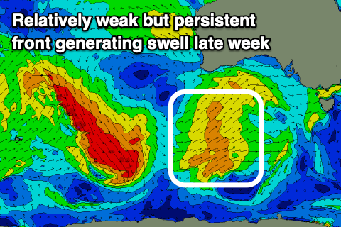 A cold front moving in high through the Bight this evening and tomorrow will produce a short-lived burst of strong W/SW winds in our western swell window tomorrow evening, moving across us Wednesday.
We'll see a gusty but easing W/SW breeze on Wednesday and building surf to 2ft to likely 3ft later in the afternoon on the Surf Coast and 4ft+ on the Mornington Peninsula. We may see winds tend W/NW later in the afternoon as another cold front approaches from the west, creating OK conditions for a late surf.
Thursday will be clean on the Surf Coast again with a N/NW offshore but small easing 2ft sets and bumpy 3ft to maybe 4ft waves to the east. A SW change is due through the early afternoon, linked to the secondary cold front moving through and a possible late increase in windswell.
A stronger W/SW swell should fill in Friday from the earlier stages of the front bringing Thursday's change, that being a broad fetch of patchy strong to near gale-force W/SW winds projecting towards us through our western swell window tomorrow and Wednesday.
Size wise we should see the Surf Coast building to 3-4ft at magnets into Friday afternoon, smaller and likely more 2-3ft in the morning, with the Mornington Peninsula increasing to 5-6ft+ or so. Winds unfortunately look poor in the wake of Thursday's change with moderate to fresh from the SW, possibly W'ly for a period early morning.
Saturday should become cleaner ahead of another front with an all day offshore W/NW breeze and easing surf from 3ft to maybe 4ft on the Surf Coast and 5-6ft to the east.
 Sunday is a tricky one firstly with the local winds swinging from a gusty W/NW'ly to the W/SW-SW around midday with another passing front.
A mix of new swells are due to build into the afternoon arriving from pre-frontal NW fetches, polar W/SW fetches, the later producing the best swell for Monday.
When winds are offshore Sunday morning, size wise we'll be in between swells and likely only see surf to 2-3ft on the Surf Coast (with our models incorrectly combining a distant long-period signal with mid-period swell).
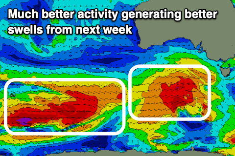
Monday should see better surf to 4-5ft on the Surf Coast and 6-8ft on the Mornington Peninsula with excellent N/NW offshore winds. From here on through next week and beyond we'll see the westerly storm track set in motion with a conveyor belt of polar and mid-latitude fronts due to move in under the influence of a elongated and zonal Long Wave Trough. More on this Wednesday though.
Comments
West Coast gets a good summer. Wheres the fucking balance for us.
Yeah fuckin oath, thats more like it. UTCFB
Yeah, couldn't agree more. Down to the clubhouse on friday night maybe?
Hahaha.
Good summer? Didnt feel like it!