Lots of swell to come with workable winds for both regions

Victoria Forecast by Craig Brokensha (issued Wednesday 17th April)
Best Days: Surf Coast tomorrow morning, beaches to the east later morning/early afternoon Friday, beaches Saturday, both coasts Sunday, Surf Coast Monday morning, both coasts Tuesday morning
Recap
Tiny to small waves across all locations yesterday with favourable winds for the beaches, similar this morning though there are tiny lines of new groundswell starting to show on the coast.
We'll see a new inconsistent W/SW groundswell arriving later today with the Surf Coast hopefully reaching 2-3ft on the magnets before dark and 4-5ft to the east as winds shift N/NW-NW (possibly holding out of the N east of Melbourne if we're super lucky).
Today’s Forecaster Notes are brought to you by Rip Curl
This week and weekend (Apr 18 - 21)
The inconsistent W/SW groundswell due later today should peak tomorrow morning, with infrequent but good 3ft+ sets due on the Surf Coast swell magnets and 5-6ft waves to the east.
Winds are looking at bit better for the Surf Coast and out of the W/NW until later morning, shifting S/SW thereafter and without too much strength. To the east conditions will be average with a moderate to fresh W/SW breeze, easing and tending S/SW.
Our reinforcing W/SW groundswell for Friday is still on track, with a vigorous mid-latitude front pushing into and across the South Coast of WA yesterday. It's now currently weakening while pushing through the Bight. Also in the mix will be a better aligned SW groundswell, produced by a good polar fetch of strong to gale-force W/SW winds well south of WA.
Size wise the Surf Coast swell magnets should hold around 3ft on the sets in the morning, with the SW groundswell possibly offering the odd 4ft'er from mid-late morning, with the Mornington Peninsula persisting around 5-6ft.
Winds are still looking average though as a high moves in from the west, bringing moderate E/SE breezes though we may see a period of lighter E/NE winds through the middle of the day/early afternoon ahead of SE sea breezes. So keep an eye on local observations for a wave on the beaches.
Saturday looks to be a much better bet on the beaches with a better N/NE offshore wind, holding most of the day if not tending E/NE into the afternoon.
Friday's mix of swells will be on the decline, dropping from 3ft on the sets across Surf Coast swell magnets and 4-5ft to the east. The swell isn't likely to drop below 2-3ft and 4-5ft respectively through the day though as a reinforcing W/SW groundswell fills in during the day, generated by a pre-frontal fetch of W/NW gales ahead of a strong low in the Indian Ocean.
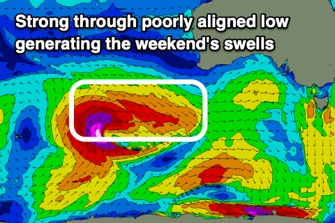 This low is currently producing a significant fetch of severe-gale to storm-force winds between Heard Island and Western Australia, but it's poorly aimed for Victoria. On its northern flank we're seeing a small area of W/SW winds in our swell window, but on the western flank all the energy is aimed towards Indonesia.
The low will weaken slowly while broadening in scope this evening, resulting in a split NW and S/SW fetch which will fall outside of our swell window.
What we can expect from this low is an inconsistent and small to moderate sized long-period W/SW groundswell which will arrive overnight Saturday and build Sunday. It's tricky to nail down the size but the morning looks smallest and to 2ft+ on the Surf Coast, 4ft or so on the Mornington Peninsula, but building to an inconsistenct 3ft and 5-6ft respectively on the sets into the afternoon. Winds will be favourable for the beaches through the morning with a gusty N/NE'ly, shifting N/NW late morning/midday and then W/NW through the afternoon ahead of a possible late onshore change.
 Next week onwards (Apr 22 onwards)
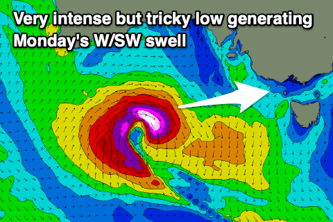
Sunday's inconsistent W/SW groundswell will ease through Monday, but a new close-range W/SW swell will take its place.
The remnants of the split storm generating Sunday's swell will re-intensify south of the Bight and produce a tight fetch of W/SW gales in our western swell window while dipping south-east.
Another tricky W/SW groundswell should be seen off this low, peaking Monday morning to 3-4ft on the Surf Coast and 6ft+ on the Mornington Peninsula. Winds look best for the Surf Coast with a morning W/NW breeze, shifting SW through the day.
A drop in swell is likely Tuesday as winds tend variable out of the SE.
Longer term we've got more long-range and moderate sized W/SW groundswell due from mid-late week, but more on this in Friday's update.