Average weekend, good westerly swells mid-late next week

Victoria Forecast by Craig Brokensha (issued Friday 12th April)
Best Days: Late Wednesday exposed beaches, Surf Coast Thursday morning and beaches Friday
Recap
Light winds and fun workable waves easing back from 3-4ft on the Surf Coast yesterday, better on the Mornington Peninsula into the afternoon with more water on the banks and variable breezes.
Today the swell has cleaned right up across most spots with easing 3ft of S/SW swell on the Surf Coast and 3-4ft waves on the Mornington Peninsula. Winds should remain favourable for most locations into this afternoon as the swell continues to drop.
Today’s Forecaster Notes are brought to you by Rip Curl
This weekend and next week (Apr 13 - 19)
The weekend and early next week is still fairly hit and miss, with small flukey swells and OK but not ideal winds.
Tomorrow will provide a tiny window of fun waves on the exposed beaches with a dawn N'ly and fading 2ft+ waves on the Mornington Peninsula, possibly 1-2ft at swell magnets on the Surf Coast, but most likely smaller with an early NW breeze.
A mid-late morning SW change will create poor surf for the rest of the day. So all in all tomorrow is a lay day.
 Our small and inconsistent W'ly groundswell for Sunday is still on track, with it impacting Western Australia today. Margs has jumped rapidly in size, but the storm linked to this swell was fairly north in latitude and west in location, resulting in an inconsistent westerly swell for our state.
The Surf Coast isn't likely to offer any size at all with infrequent sets building to 1-2ft at spots open to the acute west swell, and a local building E/SE windswell from easterly winds through Bass Strait looks to be more noticeable.
The Mornington Peninsula will hopefully see inconsistent sets building to 3ft through the day, though E'ly winds will favour only selected breaks, shifting E/SE through the afternoon.
Monday will be cleaner with a NE offshore, though the swell will be on the ease from an inconsistent 2-3ft on the Mornington Peninsula and easing E/SE windswell from 1-2ft on the Surf Coast.
The swell will bottom out through Tuesday and Wednesday morning as strengthening N/NE winds keep conditions relatively clean. The Mornington Peninsula should still offer an inconsistent 2ft wave Tuesday morning from a distant storm, but otherwise there's nothing of note.
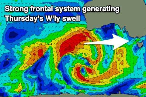
We then look to our tricky W'ly swells due mid-late week, generated by strong polar fronts being steered up and across Western Australia by a strong node of the Long Wave Trough.
The first storm will form around Heard Island and project a great fetch of severe-gale W/SW-SW winds north-east up towards WA, on the periphery of our western swell window. The front will then push under the WA coast and weaken while remaining in our western swell window.
A moderate sized and acute W'ly groundswell will be generated, with it likely to arrive very late Wednesday, though peak Thursday morning to 3ft+ on Surf Coast swell magnets and 5-6ft on the Mornington Peninsula.
Winds look favourable for the Surf Coast as a trough slides in from the north-west, bringing a gusty W/NW tending W/SW-SW breeze.
We may see an additional W/SW windswell in the mix from this trough, but we'll have to review this Monday.
A secondary front pushing up on the tail of the first one projecting towards WA looks to generate a reinforcing W'ly swell for Friday but the structure of this sytem is patchy and the models are still a little divergent regarding this. A polar fetch of W/SW gales attached to this storm may also generate a fun SW groundswell Friday, but in any case we'll see Thursday's swell easing though with a return to NE winds as a high moves in.
Longer term the models diverge on what's expected into the weekend and beyond, but we'll likely see a renewal of W/SW groundswell Sunday, though we'll have to have a closer look at this Monday. Have a great weekend!
Comments
Geez it was nice today!
One mans Piss trough is another mans hot springs.
Trough man
Pumping station on the cook huh?
Amazing how a S-S/W swell keeps the surfcoast ticking away quite nicely, shame the seabreeze has spoiled it.
Pt. Nepean buoy is down.