Fun waves as the swell fades, average until at least mid-next week

Victoria Forecast by Craig Brokensha (issued Wednesday 10th April)
Best Days: Surf Coast and Phillip Island tomorrow morning, exposed beaches Friday, exposed beaches Monday morning
Recap
Pumping surf into Monday evening with the swell pushing in large and strong, groomed by an easing offshore wind on the Surf Coast, while yesterday the surf was a little lumpy though good early with surf to 6ft or so on the magnets. A peak in size was seen through the day though with a swing in onshore winds and raw 6-8ft surf, bigger to the east.
Today the swell is on the ease with good fun 4-5ft waves around Torquay, poor to the east and only workable in selected spots.
Today’s Forecaster Notes are brought to you by Rip Curl
This week and weekend (Apr 11 - 14)
The surf should continue to ease into the end of the week, though slowly owing to reinforcing mid-period S/SW swell energy filling in tomorrow afternoon. A broad and elongated fetch of strong SW winds behind the main swell generating front has generated this mid-period swell and winds should become lighter and improve for the beaches Friday.
Tomorrow morning conditions should be good on the Surf Coast and around Phillip Island with light variable winds (likely tending W/NW around Torquay) while the Mornington Peninsula looks to be bumpy with a lingering onshore S/SW wind. Size wise a slight drop from 3ft+ at magnets is expected on the Surf Coast, 4-5ft+ to the east.
Friday looks great on the exposed beaches across the state with a N'ly offshore and easing 2ft+ sets on the Surf Coast magnets, 3-4ft to the east.
As touched on in Monday's notes, the weekend will start average with the swell becoming small to tiny on the Surf Coast though clean with a light NW offshore ahead of SE sea breezes.
 Sunday/Monday are looking a little hit and miss but there should be some OK options across exposed beaches that handle an easterly wind.
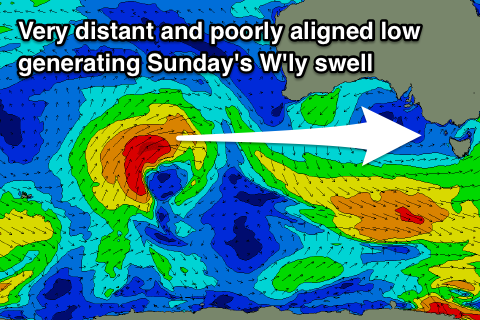
A long-range and very inconsistent and west swell is due to fill in Sunday, generated by a strong but distant low that's currently projecting a fetch of strong to gale-force W/SW winds towards Western Australia. The low is a bit too far north of our swell window and will weaken significantly once dipping more favourably south-east into our swell window.
As a result I wouldn't expect much on the Surf Coast over an inconsistent 1-2ft, mixed in with a poor local E/SE windswell to a similar size. The Mornington Peninsula should build slowly to an inconsistent 3ft or so but with E/SE tending E'ly wind, E/SE later in the day.
Monday looks cleaner with an E/NE-NE offshore but small easing surf from a similar 3ft on the beaches, 1-2ft on the Surf Coast.
Longer term, we'll see a strong node of the Long Wave Trough developing across Western Australia, directing strong frontal systems up into their region, too far north and not ideal for Victoria.
This will result in inconsistent W'ly swells from mid-late next week though with favourable winds more so for the beaches than the Surf Coast reefs as detailed in the Rip Curl Pro Early Forecast, but we'll have a closer look at this on Friday.
Comments
'Craig' Sorell is back up! Feels like I just found my car keys or something......Phewww.
Haha, can totally relate!
The long range forecast is now looking half decent
Still moving around too much to make a call.