Exciting period with a good SE swell with favourable winds

Victoria Forecast by Craig Brokensha (issued Wednesday 12th December)
Best Days: Both coasts early tomorrow morning, both coasts through the day Friday and Saturday, Surf Coast early Monday
Recap
The surf hung in around 2-3ft across Surf Coast magnets yesterday morning with workable weak onshore winds, 3-4ft and bumpy to the east. A slight kick in size was seen through the afternoon but with average conditions under fresher sea breezes.
Today the surf is a touch smaller but hanging in at 2ft on the Surf Coast and 3ft to occasionally 4ft to the east with much cleaner conditions on the beaches. Winds look like they'll remain favourable all day and we should see some new swell starting to show later this afternoon, providing fun waves for the late session.
Today’s Forecaster Notes are brought to you by Rip Curl
This week and weekend (Nov 13 - 16)
The swell due later today should perk wave heights up to 2ft+ by dark on the Surf Coast and 4ft+ to the east along with favourable winds, peaking tomorrow morning. The swell impacted WA later yesterday and this morning, coming in on forecast, and when it peaks across our region we should see infrequent but good 3ft waves on the Surf Coast, with 4-5ft sets to the east.
Winds are looking favourable for both coasts early-mid morning tomorrow with a variable tending NW breeze on the Surf Coast, and N'ly tending variable winds on the Mornington Peninsula before a SW change starts moving through mid-late morning though without too much strength.
Now, our broad and dynamic mid-latitude low that's expected to form across the state tomorrow and stall across inland NSW through most of the weekend is still on track, and its positioning is now looking more favourable for us in terms of local winds.
Into Thursday evening and Friday morning a fetch of strong to gale-force E/SE winds will be generated through south-eastern Bass Strait.
The southern axis of the low will shift south through the morning though and this will result in winds tending variable and likely northerly from early-mid morning and remaining so most of the day. This trend may be a little slower across the Mornington Peninsula and more so Phillip Island.
Swell wise, we'll see Thursday's swell easing back from 2-3ft on the Surf Coast but a new SE windswell is due to build to 3-4ft through the day. The Mornington Peninsula looks to offer a mix of swells to 3-5ft.
With the SE windswell and variable winds, there should be some fun funky waves on offer across both regions through the day.
Saturday will see the low weaken while remaining just south enough to create variable winds and conditions again during the day.
We'll see the SE windswell easing though from 3ft to maybe 4ft early on the Surf Coast and 3ft on the Mornington Peninsula, small to tiny Sunday as winds revert back to the N-N/NW.
Our new long-period W/SW groundswell due later in the day ahead of a peak Monday is still on track, with the storm forming already around the Heard Island region.
We're seeing a fetch of severe-gale to storm-force W/SW winds, with the low expected to broaden slightly while weakening a touch to the south-west of WA, breaking down once south of the state.
An inconsistent but good W/SW groundswell should be generated, building later Sunday to 2-3ft on the Surf Coast swell magnets and 3-5ft to the east, peaking Monday to 3-4ft and 5-6ft respectively. Winds look dicey and onshore from the SW, but likely early W/NW around Torquay. More on this Friday.
Comments
Strange or perhaps not, that a event like this has happened around this same time of year. This would be i think the 3rd in 4 years.
These systems have been pretty common on the surf coast over the years for Christmas/New Years. I remember as a kid every second Christmas there'd be an Easterly that dumped a shit ton of rain in the Otways. Perfect timing for all those Melbournites paying top dollar holiday rents to sit inside and watch the rain.
Pretty sure the system that caused The Falls relocation was actually a fire in the Otways followed by more extreme hot weather over the new year period..
Gary is trembling with anticipation with the news that his exposed sections are going to cop it from a different angle this weekend.
Variety is the spice of life
Forecast ain’t gettin me very excited.
There are a few sand points around that are pretty junky but fun in an east/se swell. Don't get me wrong? by no means epic but it's better than not surfing.
There was a day a few years back when an unconventional swell hit (may have been a couple of swells in the mix) and a long stretch of coast which normally gets swell pretty straight became somewhere like D-bah. Haven't seen anything like it since.
Sick BR! I'll be searching around for some novelty waves for sure.
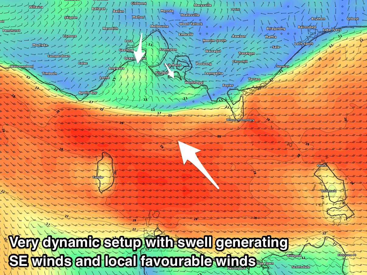
An update on this dynamic system.
Looks like the low will sit a touch too far north and bring SE winds most of tomorrow, but a larger increase in SE windswell.
There is the chance for a short period of localised variable winds from Torquay to around Rye as shown below (8am) but I wouldn't count on it.
Saturday is still looking fun with more variable winds due to develop through the day.
Another model update and we're back to our outlook from yesterday.
With such a tricky system you'll have to keep an eye on the local winds and radars to make a call tomorrow..