A glimmer of hope for the weekend, better mid-late next week

Victoria Forecast by Craig Brokensha (issued Friday 7th December)
Best Days: Exposed beaches tomorrow morning, east of Melbourne keen surfers Tuesday morning, but more so Wednesday morning, Surf Coast Thursday morning
Recap
Fading surf yesterday, tiny on the Surf Coast and small but worakble on the Mornington Peninsula with offshore winds.
Today the swell has bottomed out leaving nowhere to surf with size, under a hot offshore wind.
Today’s Forecaster Notes are brought to you by Rip Curl
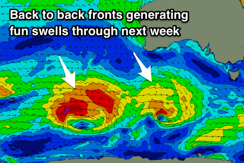
This weekend and next week (Nov 8 - 14)
Later today we may see a hint of new W/SW swell, but we'll see the peak through tomorrow morning and we've got a window of cleaner conditions due across both coasts. Dawn doesn't look great with a possible SW'ly, but this will tend variable and likely N/NE through the morning ahead of a SW change late morning (though not too strong) as a surface trough moves in from the west.
Size wise the Surf Coast will be very inconsistent and only around 2ft, with an outside chance for the odd 3ft'er at swell magnets, while the Mornington Peninsula should come in around a better 4ft on the sets, though you'll have to be patient.
Come Sunday fresher S'ly winds and a drop in swell will create poor conditions, while on Monday we're due to see our better W/SW groundswell fill in, but with with S'ly winds persisting on the coast.
This swell has been generated the last couple of days by a strong polar front projecting up towards Western Australia, with it currently weakening while pushing east under the country today.
 The swell should start building later Sunday afternoon, peaking Monday morning to a more consistent 3ft on the Surf Coast and 4-5ft+ to the east, though messy with those onshore winds.
Conditions should improve into Tuesday across the beaches, but it'll still be lumpy and bumpy with a light to moderate E/SE breeze.
The swell will be on the ease but slowed by a reinforcing W/SW pulse, generated by a weak front pushing up towards WA and then under the country tomorrow and Sunday morning.
2-3ft sets should still be see on the Surf Coast, easing through the day, with 4-5ft sets on the Mornington Peninsula.
Wednesday morning looks the pick with a touch less size but better offshore E/NE-NE breezes. The Mornington Peninsula will likely be around 3-4ft, smaller and to 2ft or so on the Surf Coast, but into the late afternoon and more so Thursday a new pulse of W/SW groundswell should fill in.
The source of this swell will be a relatively weak but prolonged polar front moving in from the Heard Island region, generating persistent W'ly gales through our western swell window.
Size wise we're looking at a kick back to 3ft on the Surf Coast and 4-5ft on the Mornington Peninsula and with W/NW winds as a surface trough approaches from the west, bringing a change into the afternoon and what looks to be poor winds and a SE windswell next weekend.
Therefore make the most of Wednesday and Thursday mornings windows of clean conditions before the onshore winds kick in again. Have a great weekend!
Comments
There will probably be a bit of pepper on that SW change tomorrow i imagine?
Actually not too bad, initially 10 to maybe 15kt max but backing off a little after this initial change, so it'll remain workable.
Even with this hot wearher? Hot + cold = bam,
Obviously not exact science but just anecdotally..
Yeah, it's only a weak trough bringing a slight cooling trend and weak change, with a colder burst of air into Sunday.
Wind line approaching
That didnt have much bite
Ok, the summer duldrums are in full effect, I really wish we had one of those bloody wave pools to make it through this summer s#@t. I'd pay $100 maybe more for a 1 hour session in any of the prototype pools atm
Why not go for a drive either side of where you are instead?
Your right GF but there just hasn't been a decent string of days in a row to make the effort worthwhile. The swag and gear is always ready to go at a moments notice but when will the stars finally align? hopefully this Christmas break will provide the goods......