A small glimmer of hope

Victoria Forecast by Craig Brokensha (issued Wednesday 21st November)
Best Days: Desperate surfers east of Melbourne dawn tomorrow, Surf Coast through the morning
Recap
Tiny waves on the Surf Coast yesterday morning with clean though inconsistent 2-3ft sets on the Mornington Peninsula. A strong onshore change moved through during the afternoon though ran out of steam late on the Mornington Peninsula with winds going variable again.
This morning a slight increase in weak W/SW swell has provided a little more size to 1-2ft on the Surf Coast for desperate surfers, onshore and poor to the east.
Today’s Forecaster Notes are brought to you by Rip Curl
This week and weekend (Nov 22 – 25)
Looking at the swell due tomorrow morning across the region and we're due to see similar sized surf to today though with a touch more energy.
Size wise we're only looking at small inconsistent 2ft sets at magnets on the Surf Coast, with 3ft sets on the Mornington Peninsula.
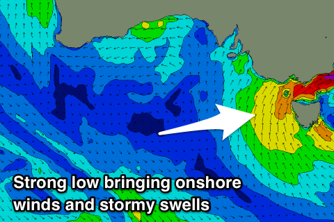
A dynamic and deepening mid-latitude low looks to slow slightly on its movement east and with this we're due to see a window of clean conditions on the exposed beaches to the east.
A dawn N'ly breeze should be seen, tending NW through the morning ahead of SW change through the afternoon, strengthening later in the day as the low moves further east.
Into Friday we'll see poor conditions with strong SW winds and building levels of SW-S/SW swell as the low stalls off the Tassie East Coast.
Size wise we'll likely see Torquay building to 4-5ft+ into the afternoon though with no real quality, and stormy 6ft+ waves on the Mornington Peninsula. The Torquay region may see an early W/SW breeze but you'd have to be super desperate.
 The low will start to weaken on Saturday and with this winds will ease but still be fresh to strong from the S/SW, abating through the day. There's a very slim chance for an early W/SW breeze around Torquay again, with easing surf from the 3-4ft range, 5-6ft to the east.
Winds look as if they'll shift to the E on Sunday morning as another mid-latitude low starts moving in from the west, but there's no decent swell due to be left on the coast.
The windswell will continue to ease, and a bump in size shown by the models is an incorrect combination of a distant mid-period swell and the easing windswell.
We're only expected to see easing 2ft waves on the Surf Coast, 3ft max to the east.
The surf will continue to ease into early next week owing to the blocking nature of the mid-latitude lows across southern Australia through the weekend and early next week.
We're likely to see yet another mid-latitude storm pushing through our swell window early next week but this will be too far north and out of our swell window to generate any meaningful swell.
There are some indications that we'll see a better groundswell longer term into the first weekend of December but check back here on Friday for more on this.
Comments
Hi Craig will it be lumped up wind swell Sunday morning or will there be ground swell in the mix?
There'll be some small groundswell in the mix but it will be very inconsistent and the leftover windswell will likely be most evident. Not great at all.
Lowest barometer readings I've seen across the coast in a while, around 993hPa.
Western flank of the low now starting to impact Portland, winds are S/SE gusting 27kts.
Cape Jaffa (SE Coast of SA) was S/SW gusting 44kts a few hours ago. The barometer dropped to 988.3hPa there around 10:30pm, but is now at 1001.3 - that's a 13hPa increase in ten hours.
Still light and variable across the rest of the state though.. but not for long.
Erm, winds have gone from fresh to strong S/SE at Cape Nelson (Portland) to moderate NE.
Westerlies now kicking in at Cape Otway though, not much strength (gusting 19kts) but it's a promising sign.