Good though not pumping waves over the coming days

Victoria Forecast by Craig Brokensha (issued Friday 5th October)
Best Days: Both coasts Saturday, beaches Sunday and Monday, possibly Tuesday morning swell magnets
Recap
The large long-period SW groundswell came is as forecast yesterday with macking waves on the exposed beaches but with poor onshore winds, only surfable in super protected spots.
The swell has eased overnight and is dropping slowly today with poor SE winds.
Today’s Forecaster Notes are brought to you by Rip Curl
This weekend and next week (Oct 6 - 12)
Yesterday's large SW groundswell event is on the ease, but a reinforcing S/SW groundswell is due to slow this easing trend into this afternoon and tomorrow, generated by a trailing polar frontal system in the wake of the severe-low that generated the initial swell.
The Surf Coast magnets should still see 3ft to occasionally 4ft sets tomorrow morning, easing through the day with 4-6ft sets to the east.
Winds will improve from tomorrow with light local offshore breezes expected through the morning (N/NW Surf Coast and N/NE Mornington Peninsula), tending variable ahead of SE sea breezes.
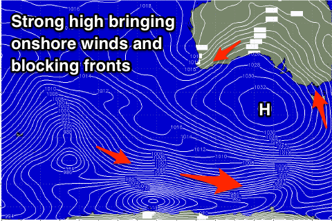
The swell will ease further into Sunday morning, with a new S/SW groundswell due to arrive into the afternoon, generated by a pre and post-frontal fetch of NW-W/SW gales moving along the polar shelf today and early tomorrow (right).
The Surf Coast magnets should continue to see 3ft sets during the morning, more consistent and possibly a touch larger into the afternoon with developing 4-5ft sets to the east. A morning E/NE-NE offshore will favour the beaches to the east of Melbourne and on the Surf Coast, with a NE-N/NE offshore due Monday morning as the swell eases from 2-3ft and 4ft respectively.
Tuesday will be smaller again and we're expected to see a morning N/NW offshore before a surface trough and strong high move in from the west, bringing a strong S/SW change.
 We'll see the surface trough combining with an infeed of cold polar air, resulting in the formation of another low pressure system off the NSW coast, but this low will be much stronger and broader than the current low.
The low will squeeze the strong high resulting in strong S/SE-SE winds and a developing SE windswell across both coasts, persisting but weakening into the end of the week.
No major new swell sources are due in this period owing to the large blocking high, so all in all the outlook is poor from Tuesday next week once the change hits. Therefore make the most of the coming days of good winds and swell. Have a great weekend!
Comments
Thanks for your reports. Could you please clarify what the "magnets" are your refer to. Eg The Surf Coast magnets should continue to see 3ft sets during the morning. Are these location geographical features?
Magnets are the areas which pick up the most swell