Ending the week with good surf, larger swells developing over the weekend

Victoria Forecast by Craig Brokensha (issued Wednesday 12th September)
Best Days: Surf Coast tomorrow, Friday all locations, Saturday morning Surf Coast, Sunday Surf Coast, most of next week Surf Coast
Recap
Great waves across the states beaches and selected reefs yesterday with freshening N'ly winds and easing surf from the 4ft range on the Surf Coast and 6ft+ to the east.
This morning it's smaller again and winds are best for the Surf Coast with a mix of westerly swell energy to 2-3ft. A new pulse of W/SW swell expected this afternoon from a high-riding mid-latitude front dipping south-east across us has been upgraded with a better fetch of strong to near-gale-force W/SW winds being aimed in our swell window this morning.
We should see consistent sets to 3ft+ into this afternoon and evening on the Surf Coast as winds hold from the W/NW.
Today’s Forecaster Notes are brought to you by Rip Curl
This week and weekend (Sep 13 - 16)
As pointed our just above, the mid-latitude front pushing down across us today has generated a better fetch of strong to near-gale-force W/SW winds in our western swell window, immediately west of Bass Strait this morning and with this we're looking at a better pulse of mid-period W/SW swell later today, easing through tomorrow.
The Surf Coast should ease back from 3ft early tomorrow, with 4-5ft+ waves to the east under a great offshore NW breeze.
Our new pulse of W'ly groundswell for later in the day and more so Friday is still on track, with a broad and elongated fetch of W'ly winds moving in from the south-east Indian Ocean over the last couple of days.
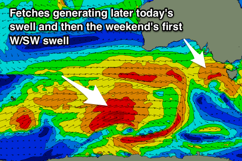 This fetch is now tending W/NW while moving closer, angling away from our swell window.
We may see this swell kicking later tomorrow, but peaking Friday morning to 3ft+ on the Surf Coast swell magnets and 5-6ft to the east.
Winds will improve a touch more for locations east of Melbourne with a fresh morning N'ly tending N/NW'ly into the afternoon, and N/NW all day on the Surf Coast.
Later in the day on Friday we may see a larger longer-period W/SW groundswell filling in, but Saturday morning is a much better chance for this.
This swell is being generated by a better aligned and slightly stronger fetch of gale to near-severe-gale W/SW winds stalling south-southwest of WA.
The W/SW groundswell should reach 4-5ft on the Surf Coast Saturday morning, with 6-8ft sets to the east under a gusty W/NW breeze, giving into a W/SW change late morning.
This change will be linked to a broad and strong polar front piggy-backing over the top of all the activity before it and pushing across us, bringing with it a larger increase in W/SW swell later Saturday but more so Sunday.
Saturday afternoon's increase will mostly be local mid-period noise, but looking back below WA over the coming days, and a flurry of gale to severe-gale W/SW and SW fetches will be generated through our western and south-western swell windows, producing a mix of large swells Sunday.
At this stage we should see the Surf Coast building to a strong 5-6ft through Sunday, with those bigger sets mostly likely from late morning with 8ft waves to the east under a much better W/NW breeze as another front approaches from the west.
Winds will swing more NW into Monday as the swell eases, dropping from 4ft on the sets across the Surf Coast and 6ft+ to the east.
A temporary low point in swell is expected Tuesday morning, but into the afternoon and more so Wednesday we're expected to see a new moderate to large long-period W/SW groundswell filling in.
This will be produced by a very strong low that's been forecast to form in the southern Indian Ocean the last few days, with it weakening while pushing under the country Sunday and early next week.
The swell looks to be met with W/NW winds, favouring the Surf Coast, but more on this Friday.