Average weekend, improving slowly next week

Victoria Forecast by Craig Brokensha (issued Friday 31st August)
Best Days: Protected spots Surf Coast Saturday morning keen surfers, Tuesday exposed beaches and early Wednesday
Recap
Great waves on the beaches to the east of Melbourne yesterday with a good new long-period SW groundswell to 4-6ft with offshore winds, a bit wind affected even on the Surf Coast beaches and to 3ft+.
The swell eased through the day and has bottomed out this morning as expected, leaving small to tiny waves across all locations. We should see a new S/SW groundswell arriving this afternoon and boosting wave heights back to hopefully 3ft on the Surf Coast magnets, with 4-5ft+ waves to the east as winds swing more W/NW.
Cape Sorell has risen slightly, but not to any major size as of yet.
Today’s Forecaster Notes are brought to you by Rip Curl
This weekend and next week (Sep 1 - 7)
This afternoon's increase in S/SW groundswell will be the first of two pulses, with the secondary filling in tomorrow.
The swells were generated by pre-frontal and post-frontal W/NW and W/SW gales pushing along the polar shelf, and we should see the Surf Coast continuing around 3ft on the sets at swell magnets tomorrow morning, 4-5ft+ east of Melbourne.
Winds will be generally average and out of the W/SW-SW, though the Torquay region should see a morning W/NW breeze.
Our models have backed off the late increase in size that I thought was in error, but moving into Sunday our large and powerful SW tending S/SW groundswell is still on track, but so are the poor winds.
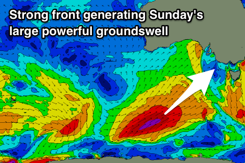 Yesterday afternoon a vigorous polar front formed south of WA, with a great fetch of SW gales already being aimed through our south-western swell window.
Models have upgraded the core wind speeds within this fetch and we'll see severe-gale SW winds projected towards us and then through our southern swell window before the front starts to weaken while passing across Tassie tomorrow afternoon and evening.
A large long-period SW tending S/SW groundswell will result, filling in Sunday and reaching an easy 6ft+ on the Surf Coast and 8ft+ on the Mornington Peninsula. Winds look poor though and fresh and gusty out of the S/SW, with only the smallest chance of an early W'ly around Torquay, not worth the drive from Melbourne.
The front will clear off to the east overnight Sunday and with this winds are expected to ease but likely persist out of the S/SE on Monday. There's a chance for more variable breezes but there'll be a lot of leftover lump and bump on the coast.
Solid but rapidly easing sets from 4-5ft are due on the Surf Coast, with 6ft+ sets to the east, better on Tuesday with a N/NE offshore as a strong slow moving high slides in from the west. Some reinforcing SW swell is due to slow the easing trend, produced by a less than favourably aligned by strong and persistent fetch of W/NW gales moving in south of the Bight over the weekend.
The polar low isn't on the cards anymore, but we should see sets hanging in around 3ft on the Surf Coast and 4-5ft on the Mornington Peninsula easing off later and more noticeably through Wednesday with stronger N/NE winds.
We're due to see the swell bottoming out into Thursday with no major surf due until later in the week/weekend owing to the strong slow moving blocking high.
This new swell looks to be W/SW groundswell from a strong polar front pushing up towards WA over the weekend and early next week. A mid-latitude low spawning off this front is due to move in around the same time as the swell, possibly spoiling conditions, but more on this Monday. Have a great weekend!
Comments
G'day Craig, down from Byron visiting mates n family and hanging for a wave. Will it be worth heading to the surf coast tomorrow morning for an early one?
Sunday looks like a write off and monday doesn't look to great either :(
Cheers mate
Yeah in that period, I'd try early tomorrow, just keep your expectations low.
Thanks mate, here's hoping !
If you're coming down here tomorrow you'd be better off bringing your golf clubs and a stubby holder.
Winds look NW overnight tending W until about 9am, woulda thought that would keep things clean and with a decent swell that should be in the water i figured it'd be worth the trip down.
It's light NW here right now at 11.15pm. I hope you're on the money adsi cause I'm keen for some waves myself.
Super solid swell today some spots breaking that don’t usually
yep shame about the wind.